A Kilauea/Puna update has been appended at the end of the post
Distance makes the heart grow fonder. Volcanoes are best loved from far away. The excitement of live lava is best viewed on a screen and not through the window. Of course, actual distance is good, but distance in time is also often deemed sufficient. Your house may be next to a lava flow, but if that flow is 300 years old, the chances will seem pretty good. It makes that threatening mountain into a true neighbourly volcano, viewed with affection rather than trepidation.

So it must have appeared to the inhabitants of Puna. Yes, there were lava flows around, some less than a century old. Yes, the area around the Royal Gardens subdivision had been utterly destroyed by the seemingly never-ending eruption. But that was much closer to Kilauea, and Puna should be safe. Almost 60 years of quiescence was a pretty good sign. And Puna is a really interesting place to live. The forest is absolutely beautiful, and the tropical gardens could grow anything (including, admittedly, some fierce mosquitos). The area was initially quite isolated and the community self-sufficient: it was a good place for people with an independent, self-reliant attitude. Not everything was paradise, and the distinction between rich and poor could be pronounced. Development had accelerated with time, with more and more houses and industry. Part of the forest was cut to make way for farming. The geothermal plant generated 20% of the Big Island’s electricity. And still it was not a bad place to live. At least, until May 3rd, 2018 when the first fissure opened and the gardens started to grow flowers of quite a different kind.
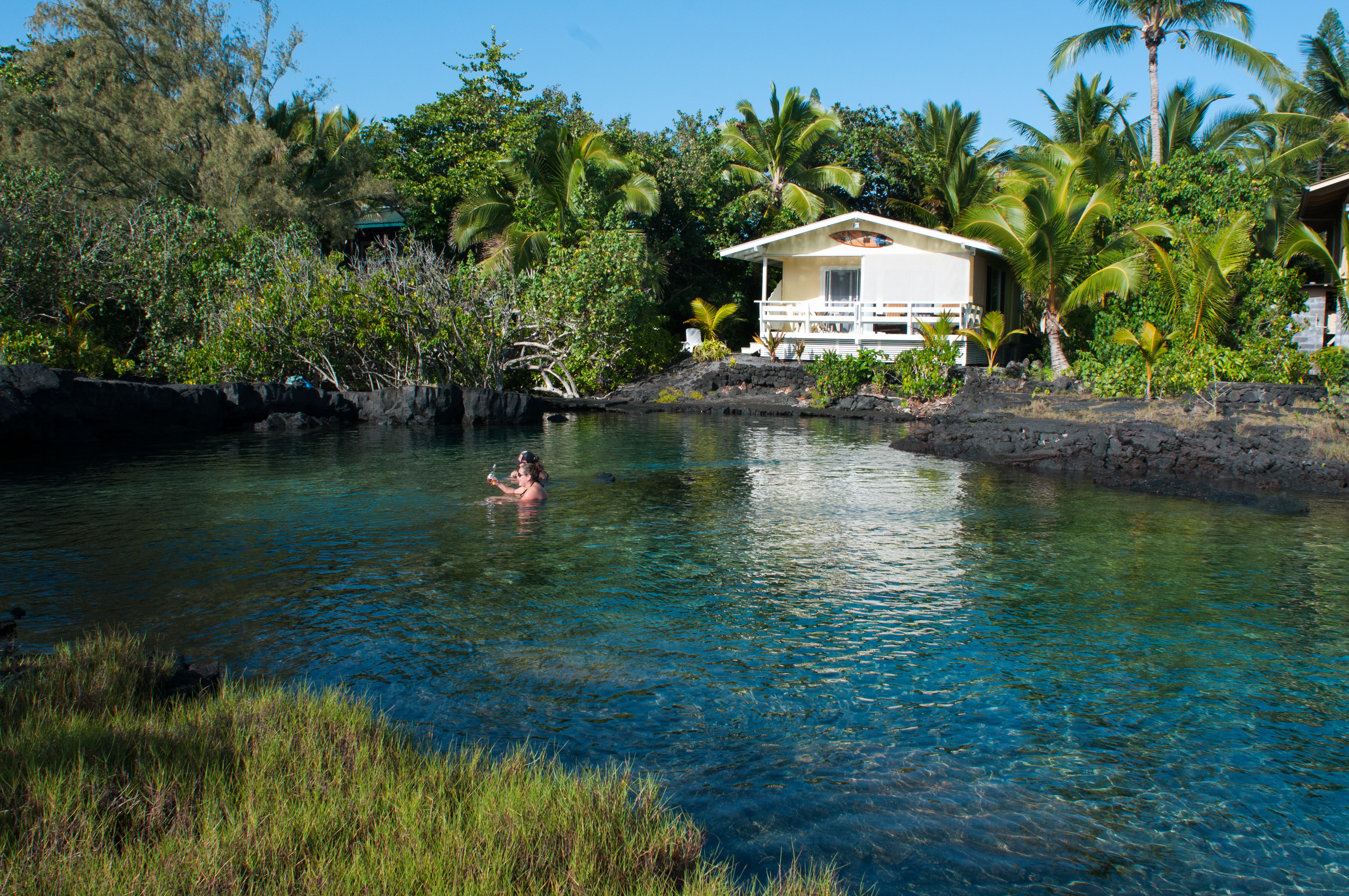
Puna: Pele’s paradise
But how secure should the people have felt? Was this eruption bad luck, or was it waiting to happen?
The map at the top shows the elevation. Mauna Loa is the elongated elephant. Kilauea is the bump just below it, on its flank. The site of Pu’u’O’o is indicated by the red arrow. The east rift is clearly seen. Mauna Loa is known for its long rift. But Kilauea is not bad either! This volcano is not just a pretty summit. It too has a long reach. Before 1950, summit eruptions were the norm. Since 1950, the summit has done rather little and eruptions have tended to come from the east rift, dominated of course by Pu’u’O’. The entire east rift is a staggering 125 km long, over half of which is beyond Puna in the ocean. The part between Pu’o’O’o and the tip of Puna, Cape Kumuhaki, is sometimes called the Lower East Rift Zone, or LERZ for short.
The LERZ is a little over 20 kilometers long and a few kilometres wide. It forms quite a pronounced ridge, slowly declining in elevation from over 500 meters near Pu’u’O’o to sea level at the coast (admittedly this states the obvious). The ridge stands 50 to 150 meters over the surroundings, and is built by spatter from the many eruptions. Individual cones may be as high as 60 meters. On the southern side the slope is much steeper than on the north: this is caused by the tendency of the south side to slip towards the sea, as also happened earlier this month. Lava goes either northeast or south/southeast, depending on exactly where on the ridge it originates. It is often a close call. Most of the eruptions have been from long rifts similar to the current one. The rifts tend to form a line of rift segments rather a single rift. The segments are not entirely aligned: they tend to show sidesteps, 10-100 meter sideways. Rifts on the northern part of the ridge tend step towards the left, and ones on the southern side step to the right, in both cases diverging a bit from the ridge further along the LERZ. However, towards the eastern end, the southern rifts can become left stepping, towards the north. There are other types of eruptions. There is one large shield (Heiheiahulu), very similar to what Pu’u’O’o has done and in fact not very from that location, covering the area directly to the coast. There is also one explosive crater, 1-km wide Kapoho. It is only just above sea level, and so it is likely that the explosion was caused by sea water intruding into the rift. This was not a minor event: an area of 6 km2 was covered by its pyroclastic flows.
Let’s look at some of the more recent eruptions. Historical events began with the 1790 eruption, although there are oral stories among the Hawaiian of older eruptions.
The 1790 eruption was one of the defining outbursts of Kilauea, with deadly pyroclastic explosions at the summit. But the eruption also involved the LERZ where it was a major event. It formed not one but two rifts, 1-2 km apart, one on the southern side and one on the north. The southern rift was over 8 km long and the northern one a massive 13 km; both are segmented (‘echelon’) with side stepping. The flows cover 35 km2 and the volume in the LERZ area is about 0.12 km3. The crater of Kilauea may have formed in the 1790 eruption, but only a small fraction of the evacuated magma has come out in the LERZ.

Lava from the 1790 eruption. Source: Bull Volcanol (1992) 54:475-483
The next major eruption was in 1840. It erupted from a northern rift, 7.5 km long, with a couple of vents about 1 kilometer further north, somewhat away from the ridge. The lava flowed northeast-ward and covered some 20 km2. Where it reached the ocean, a cone formed, build by explosions as the lava hit the water. The total volume of the lava was around 0.15 km3.
The 1955 eruption, described in the previous post, came from a southern rift, 16-km long which included a 2.5-km gap which did not erupt – which is where the 2018 eruption is occurring. It was slightly smaller than the 1840 eruption, covering 16 km2 with 0.11 km3 of lava. It reached the ocean in two areas.
Sofar, the 2018 eruptions have covered 1.3 km2. The volume is still less than 0.01 km3. We are still very far from 1790 territory!

The 1960 eruption came from a short segment, 1-km long, at Kapoho which was where the 1955 eruption had terminated. It followed on from an eruption at Iki, and like the current eruption, the rift eruption was accompanied by deflation at Kilauea. The lava covered 10km2 and amounted to 0.12 km3.
There was a short eruption in 1961, which covered about 1 km2 in the western part of the LERZ and lasted one day. And nothing since. There were three eruptions in 7 years, but nothing for 115 year before, and nothing after until now, a gap of 57 years! The frequency of eruptions in the Puna area seems slightly irregular. The south side of the ridge had no lava flows for 165 years. No wonder people felt safe. The period 1955-1961 seemed the exception, and the time since, the rule. Of course, Leilani was built on the ridge itself so it had twice the risk – but twice a very small chance still seems a very small risk (of course people who play the lottery think exactly the opposite: the potential reward skews the perception of chance.) 20% of Puna was covered in lava flows less than 250 years old, but most of that happened 200 years ago. That was a different age, wasn’t it?
But history tends to repeat itself. What does the older history have to say? What was the real risk of building in Puna?

Puna’s past
All of Puna is lava. The lush growth conceals this well but look underneath and even the rain forest is built on lava. In this climate, it doesn’t take long for lava to green. The first plants germinate within months (although the heat on the black lava can be pretty hostile until some shade develops) . Trees can grow on 40-year old lava, and after that, only the height of the trees betrays the youth of the lava.

Sprouting coconut trees . Photo by Donal McGowan
Carbon dating has been applied to many of the lava flows here, and this has shown a surprising picture. It seems that the past 250 years have been a bit of an anomaly.
Before 1790
Let’s go back a little more. A total of 15 different eruptions are dated to the 200-year period before the 1790 eruption. This includes the explosion of the Kapoho cone. It also contains the shield of Heiheiahulu, which covers a surface area of 45 km2. That eruption started as a short fissure, before building a large cone which at the end collapsed and became a pit crater. Heiheiahulu is very much like Pu’u’U’o. Local stories suggest that it erupted somewhere between 1700 and 1750, and if it is indeed a Pu’u’O’o copy, it may have lasted years. The volume is probably of order 1 km3, which is a few times less than Pu’u’O’o.
Also interesting is a flow from Ai-laau, a vent to the northwest of Kilauea. This produced a flow which made it to Puna, covering the region northwest of the ridge. The flow cover 100 km2: the summit still can outcompete the rift! It also shows another truth about Puna: while the southern and northeastern part are at risk from the LERZ, the area north of the rift is affected by eruptions from near the summit of Kilauea. This is another eruption mode we haven’t seen for some time, but it will re-occur – eventually.
Including these three, a total of 15 separate events have been identified for this period of time. In total they cover 50% of Puna. Ai-laau and Heiheiahulu are by far the most voluminous: excluding them, the rest amounts to about 1 km3. Clearly, the 200 years before 1790 was a scary time in Puna.
Before 1600
Going back another 250 years, eruptions become even more frequent. In the time period which runs roughly from 1300 to 1600, at least 20% of the area of Puna was resurfaced. It may have been much more, since the later flows will have covered up much of the evidence. A staggering number of 54 eruptions have been identified in this time zone. For about half we know where they came from, as we have found the spatter cones at the origins. For the others, the point of origin is buried under younger flows. The eruption of the spatter cone of Puu Kaliu came from a fissure about 1.5 km long, along the southern side of the LERZ. It covers at least 12 km2, and the volume is about 0.2 km3. Puu Kaliu is just south of Leilani.

Two other eruptions were of similar size. One is dated to 490 BP (with an uncertainty of 60 years either way) and lies on top of the Puu Kaliu flows: it covered at least 18 km2 and has a similar volume to Puu Kaliu. The second is dated to 440 BP and may have formed a shield similar to Heiheiahulu, but it is mostly buried by the latter and by the 1955 lava. The cliffs at Kehena, with at least 15 separate layers, comes from this eruption. Puulena Crater is another event from this time period. It is the site of a major phreatic explosion, possibly when a rift opened underneath a lake.
So this was another exciting period of time. Going back further, the record becomes more and more patchy as the evidence for the eruptions is buried underneath younger flows.
When Pele wants to play
So what can we learn from this? Some caution is required as not all dates may be that accurate. Also, some eruptions may have been double counted. For instance, the distinct flow fields of the 1955 eruption could have been counted as two different eruptions with these methods. But overall, it appears that the eruption frequency at Puna has been much higher between 250 and 800 years ago than it has been since. It also seems that the long duration of the Pu’u’O’o eruption is not that exceptional. There have been other longer-lived rift eruptions in the past.
Since 1790, the LERZ has erupted on average once every 50 years, although the intervals have been highly variable. Before that, the eruption frequency was closer to once every decade. And even though the individual volumes aren’t huge, peaking at 0.1-0.2 km3 with most eruptions considerably smaller, at this frequency Puna was rather quickly covered in lava. Almost the entire surface is less than 800 years old. Build a house anywhere in Puna, and the risk of losing it to lava is of order 20% per century. Build it on the ridge, and that risk doubles. Kapoho, at the coast, is particularly endangered: there have been a lot of eruptions in that area, and it runs pyroclastic risks when sea water penetrates the rifts.
The average dormancy time of the LERZ over the past millennium is only about 15 years. Puna is not just a distant appendix of Kilauea. Pele loves it out here, and many of Kilauea’s eruptions push into this region. The volume may be limited, but Puna is one of the most volcanically active areas in the world and possibly the most active in Hawaii. The past 200 years were exceptional. The current eruption is business as usual. These lush gardens are built on a regular supply of molten rock. There is always a cost to paradise.
Albert, May 2018

This post is based on the paper Volcanic geology and eruption frequency, lower east rift zone of Kilauea volcano, Hawaii by Richard B Moore , Bull Volcanol (1992) 54:475-483
Kilauea update 21 May
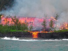
In the past few days the eruption has gone into another gear. Before, the lava was sluggish and build a ridge but had difficult going beyond that. But, as HVO has predicted, once the new lava arrived it was obvious. Fountaining was the first sign, and soon lava not just clogged but positively flowed. Lava rivers appeared and they moved fast.

A river flows through it..
The activity became confined mostly to the east-most end of the previously numbered fissures. Fissures 16 and 20 merged and became the main point of action. Fissure 17 came along but seems to fissing out. The map below is on a google map viewer. It shows that the action is just below the Puna Geothermal Plant, which presumably is now defunct. Interestingly, this plant was put in this location because of a thermal anomaly: the ground underneath had higher heat flow than other locations in the area. In hindsight, was this a warning? It is also the area that hadn’t erupted in 1955 while the ridge on either side (of Leilani) had. Now we known that the magma hadn’t skipped through: it had been stored here for later use.

A map of the active fissure and flows, as of 12 hours ago.
An estimate from the map suggests that the total flow field covers 2-3 km2 so far. A large Puna eruption tends to cover some 10 km2. We are not in that range yet. The amount of erupted lava may be around 0.01-0.02 km3. The current flow field may not get that much larger in surface area until the eruption moves to new fissures.
The fissures have fed two lobes, one of which moved though housing and farm land, and the other through rain forest. The two lobes met and split again, flowing around a kipuka and fed two ocean entries. The eastern (farmland) than found a crack and disappeared into it. What happens next depends on how big a hole it has found, but lack of steam away from it suggest it has not gone far.
Obviously, where lava enters the sea you will get steam: with this volume the lava itself actually become hard to see. The white cloud is both impressive and extremely dangerous. It contains hydrochlorid acid and minute glass particles – think asbestos. Some of the videos taken from boats look dangerously close to the plume to me. (There is a 300 meter exclusion zone which they will be obeying.) Luckily, the trade winds are blowing the plume along the coast away from people on-land (the ones still there shouldn’t be). By the weekend the winds may change and blow the plume in-land, but again, hardly anyone is left there. Along the fissure, the SO2 is very bothersome and it is unlikely to get any better. Volcanic smog is awful and a considerable health hazard.
Fissure 17 (at the far end) is now reported to have erupted andesite. That is probably not that unusual. Puna has significant magma storage and depths of 1 to a few kilometer, and some of that evolved magma has come up. Fissure 17 is at the end of the current line of activity, and so the magma it produced may have had the least amount of mixing with the new magma. There was some discussion whether it came from 1955, but there is certainly far older magma around.
What is next? The current fissures seem to be less vigorous than before and they may have peaked. Cinder cones have build up which I estimate at 30-40 meters tall: some will survive. Fissure 17 will cease shortly, I expect. HVO has reported that GPS no longer shows expansion of the rift, and so the inflow no longer exceeds the outflow – at least here. The fact that the earthquakes around Leilani have ceased also points at that. However, if the current fissures become less active, the pressure up-rift will increase and this could well lead to eruptions there. Fissure 21 is particularly worth watching. Over the next week, there is a danger of similarly fluid eruptions within Leilani, and later also further west. However, this is far from certain! Everthing south of the fissure line is at risk. Outbreaks west of Leilani could also flow northward, although it is unusual for Puna eruptions of the same rift to go both ways.
Pu’u’O’o is dead. GPS shows that the exponential decline has bottomed out: there is nothing left there to drain. It seems unlikely to ever recover, and its final fate may be that of a collapsed pit crater. But who knows, it could still surprise us in a few months.

Halemaumau has settled in a pattern: it shows increasing tremor, explodes, tremor goes away but slowly rebuilds. It is not clear to me what causes the tremor: I was wondering about boiling water.The crater size expands with the explosion but the rock quickly recovers and resumes its contraction. There tend to be a few explosions at the same minimum crater size, after which it goes to the next size. The explosions are not as strong as earlier, but this means nothing. These explosions could continue for quite some time, until the lava has risen again to above the water table. The park could be closed for some time.

I have not seen any estimates of the damage yet, apart from a few million dollars due to tourists staying away (can’t entirely blame them, but the north side of the Bg Island is also spectacularly pretty and far from any volcanic disturbance!). But in the scheme of things, that will be small fry. To compare: the Kilauea eruption of Feb 28, 1955 destroyed 21 houses, 10km of road, 4000 acres of sugar plantations and one coffee plantation, amounting to 40 million dollar at today’s prices. Mt St Helens cost 1 billion US, which is half the price of Eyjafjallajokull where the dominant cost was the continent-wide flight ban. The mud volcano in Indonesia has cost around 3 billion so far. The 2018 eruption has already destroyed more buildings than in 1955. However, most of the 1955 cost was in the lost sugar, while in the modern economy there is much less value in the land and much more in property. We can estimate that Leilani as a whole is worth 200 million US, and the geothermal plant probably around 100 million, based on its 38MW capacity. (I find it amazing that Leilani was started less than a decade after the 1955 eruption!). Double the cost to include clean-up, road rebuilding etc, and one can guess a total cost of around half a billion US. That assumes that this eruption continues for a few more weeks: if it ends soon the cost will be less.


Excellent post as ever, Albert; glad to see that someone else has not succumbed to the twin delights(?) of Royal Wedding and Cup Final I can see your post being used in evidence, m’lud, when displaced Leilani residents sue the Property Developers and estate agents/Realtors for selling them a turkey
On another note:: the development of ‘en echelon’ (parallel but offset) rifts seems to be a normal thing not unique to Puna – I seem to recall the same at the Krafla Fires, -and at the start of the Eyjawhatsitsname eruption Maybe something to do with the physics of the rifting process?
Bruce Omori helicopter flight just a few minutes ago
https://www.facebook.com/bruceomori/videos/2137756656241304/
Screenshot
Civil Beat back live
My favorite line from the terribly-fast livestream chat:
“You can’t build Rome in a day.” Hawaii: “Hold my beer …”
GL Edit: {grin}
LIve feed now with discussion what’s happening at moment.
https://www.facebook.com/milekalincoln.hnn/videos/1785464778179075/?hc_location=ufi
USG have confirmed they no longer believe lava is from the 1955 eruption but from the deflation from PU OA (apologies if spelt incorrectly).
”Pu’u O’o”
”USGS”
I think that some of the stupid in the comments burns hotter than the lava.
Yer gonna get that pretty much anywhere. After all, we are all Homo Stultus. Homo Sapiens has been effectively extinct for many years.
USGS description of the summit blast overnight is what has confused people. Many of them think the PGV plant exploded
https://earthquake.usgs.gov/earthquakes/eventpage/hv70163146#executive
M 3.0 Chemical Explosion – 5km WSW of Volcano, Hawaii
2018-05-19 09:58:33 UTC 19.405°N 155.281°W 0.0 km depth
They fixed that to just “Explosion”
Now they’ve done that the rumours will start that it is a cover-up 🙂
These fissure eruptions at Puna remind me of the Holuhraun eruption in 2014-2015. But was Holuhraun a much stronger eruption than this one at Puna?
Haha you read my mind, I also thought of Holuhraun, absolutely amazing footage right now!!
About 1000 times larger so far.
Holuhraun was much bigger than anything you will ever get in Hawaii dawnmast. Pu’u o’o did end up erupting between 4 and 5 km3 of magma, but holuhraun would have taken only about 3 years to do that instead of 30…
The closest eruption to holuhraun size in Hawaii was mauna loas 1950 eruption but even that was genuinely dwarfed.
Holuhraun was probably erupting more lava than all the other effusive volcanoes erupting on earth put together during the time it was active. The eruption rate when it was still a curtain of fire at the start of the eruption was over 1000 m3/s, the eruption in Hawaii now might be doing 80-150 m3/s but probably not more than that.
The start of this eruption was like a leaky tap, the eruption now is more like a ruptured fire hydrant, mauna loa 1950 was a burst water main, and rifting fissures in Iceland are like the entire dam bursting…
How come some fissure fountains are building cone / sides and others, right next to them, are not?
Probably has to do with the chemical composition and heat of the particular vent.
I also saw how some sides of the fissure fell down, maybe building a cone isn’t so easy?
Cones will only form where the lava is solid around the vent. If too much lava lands at the vent then it will just pond around the vent and also drown out the vents a bit. I think fissure 20 would actually have quite a high lava fountain of it wasn’t erupting through a lava pond of its own creation. Fissure 17 seems to erupt directly into the air and whatever lava erupts there (probably not that much compared to 20) flows off through a gap in the cinder cone. When the eruptions get really intense the lava fountains just blast through any lava pond and build a much bigger cone on the surrounding land beyond the pond. This happened 1983 (pu’u o’o), 1977 (pu’u kiai),1969 (mauna ulu) 1960 (pu’u laimana), 1959 (pu’u puai) and at the end of 1955 (‘T vent’), but apparently not in 1790, 1840 or most of 1955 because there aren’t any cinder cones from those eruptions for some reason. Maybe they were less gas rich and so the lava just poured out, sort of like it is now. I guess this eruption now is a bit of both at the same time, though mostly the latter mode.
Also Ikaika wants to name the cinder cone at fissure 17 pu’u palihamo, for anyone else like me who has been trying to think of a name for it 😉
” Puna is not just a distant appendix of Kilauea.”
Well, apparently Kilauea has appendicitis…
KLUD seismogram shows less tremor and quakes past hours.
KLUD – 48 hrs, source: USGS
Never mind that. Think we’ve got some kind of space-time warp going on at RSSD !
USGS put satellite images showing changes to Kīlauea caldera floor May 5–May 17 at their website
https://volcanoes.usgs.gov/volcanoes/kilauea/multimedia_chronology.html
“Major changes with respect to the May 5 image include: (1) a darkening of the terrain south of Halema‘uma‘u, which may reflect accumulation of ash over the 12-day period between the images; (2) enlargement of the summit eruptive vent on the floor of Halema‘uma‘u, from about 12 acres on May 5 to about 34 acres on May 17; and (3) the development of a small depression (area of about 15 acres) on the east rim of Halema‘uma‘u that reflects slumping of a portion of the rim towards the growing collapse pit on the crater floor.”
Credits U.S. Geological Survey

https://hawaiilavaupdate.wordpress.com/2018/05/19/lava-update-may-18-2018/
and a somewhat updated map of lava
https://www.google.com/maps/d/u/2/viewer?hl=en&mid=1CvBhH9wEeztBrqYbsGDi4YjU1k1QH5AL&ll=19.465325255604817%2C-154.8345118823288&z=18
Sorry i’m busy and haven’t had time to read everything…. was this noted here before… they say the lava in vent 17 is different than anything they have seen before in Kilauea.. http://www.hawaiinewsnow.com/story/38228382/a-small-new-york-lab-is-helping-answer-key-questions-about-kilaueas-ongoing-eruptions
Not what I would call an informative article. HOW is it different? All it says is that they receive FedEx packages and crush rock.
What, is it too Mafic? Too Felsic? ← (not likely) Say, maybe the Rare Earth Elements are so high that China might try to buy up the island.
What makes the East Rift Zone so much more active than the Southwest Rift Zone?
Hazarding a guess here. Possibly the spreading rate there is higher? Though laboriously slow, that region is flanked by the Hilina Slump.
Maybe loihi is preventing the southwest rift from moving as much. It is quite noticeable that Mauna Loa is exactly the opposite, with a long southwest rift and a short east rift, because kilauea stops it from sliding in that direction (most of the time anyway). The east rift is basically just sitting out in the ocean and has nothing to hold it back.
Mauna Loa should also be an obstacle for the southwest rift, while the east rift is a free of ultra-massive shield volcanoes.
One important thing to remember regarding Lower Puna. Though the dike of the East Rift is extruding magma here, this is not as far as it potentially could have gone. The Rift is essentially, the on-shore continuation of the Puna Ridge.
If you are into some light reading, I recommend: “Internal structure of Puna Ridge: evolution of the submarine East Rift Zone of Kilauea Volcano, Hawaii” Leslie et al (2004)
And interesting side note… the ridge to the north of the Puna ridge is the Hilo ridge. It is likely a similar geologic feature associated with Mauna Kea from back when it was the focus of activity. And probably has an older rift structure connecting to the parent volcano. (No, not saying anything is happening with it, this is just an “Oh, by the way” note.) You can even see a flattened cut-down section near the shoreline in the Gurgle Urt image that probably occurred when sea levels were lower during the last glacial max.
Ref the linked paper. Pg 254 is particularly applicable. Lower Puna would fall into the Stage 3 realm of their discussion with the (slow moving) Hilina Slump being the manifestation of the lateral displacement from the mature dike.
Note: I added “slow moving” in order to keep the easily excitable from freaking out. By “slow” I mean on human timescales. On geologic timescales, it’s quick.
The puna ridge is actually pretty deep even close to shore, if you go on google earth and sort of fly below sea level you can see that the offshore slope at cape kumukahi is pretty steep and quickly drops off to about 400 meters. This indicates that many dikes stop on land and that it might be hard to get an eruption to happen on the ridge as opposed to in the puna area, possibly a cause of why eruptions in lower puna are usually frequent compared to eruptions on the upper rift zone.
Also the Hilo ridge is the southeast rift zone of kohala volcano, and the summit of kohala was actually buried by mauna kea after it became inactive. Mauna kea apparently never had any rift zones which would be unusual for a Hawaiian volcano. It was probably surrounded by other volcanoes pretty early on and couldn’t spread in a particular direction so it became radially centered even during its shield phase and has stayed that way since then. That section of submerged coastal plain is also almost 500 meters deep too so not exposed in the last ice age (-500 meters according to google earth) but probably around 300,000 years ago it was around sea level.
On that note and also related to questions I saw on the post about haleakala, maybe some of the holocene eruptions on the north flank of mauna kea are actually from the buried summit of kohala. This would technically make every big island volcano potentially active, and also remove the apparent gap in activity where mauna kea is active, kohala is extinct and then haleakala on Maui is active again. I don’t know whether the lava from volcanoes in the post shield stage is actually chemically distinct so it might not be possible to test this but it is an interesting idea.
Very cool. Thanks!
https://en.wikipedia.org/wiki/Kohala_(mountain)
Gravity.
The fault system with the slump that extends below the seafloor makes rifting and dike injection there very easy.
It may not be. If you look at the google map below, the southwest zone is fully lava covered. The area is drier and lava stays visible longer. But clearly, this is not a low-activity zone either.
Magma will always take the path of least resistance. The slow slumping of the south of the island provides such a path along the south coast. Both rifts are now displaced to the south of where Kilauea is. That shows the growth of the island.
Eruptions happen on the southwest rift every 50 to 70 years based on the historical time period. The first eruption recorded was in 1823, then there was another in 1868 which was very small, then in 1919 and 1920, and then several that were probably related in 1971-1974. There was also an unobserved eruption in the kamakaia hills between 1790 and 1823 based on one flow overlying the 1790 ash, and another some time a few decades before 1790. Based on that it would seem plausible that another eruption could happen on the southwest rift in the next 10 years.
A deep caldera apparently doesn’t stop things happening there, as the caldera was only slightly shallower in 1823 than it was in 1790 but a big lava flow happened anyway.
Which is pretty much the same average rate as the LERZ over that time
Civil Beat guys now doing a live interview: https://www.youtube.com/watch?v=SN4ai47iNOE
Any news on if the flow has reached the ocean yet?
Not yet, but most likely some time today around the afternoon. It’s going to be one hell of an ocean entry though, basically an open lava river directly into the ocean. There are some pictures of that happening during the 2007 eruption on piton de la fournaise and it created a huge steam plume so it will be really obvious when it happens now.
Does the green line look like an S curve proxy to anyone else? 5/11-16 was the period of maximum loss, but since, the line has reverted to a similar rate as the onset. If the end of the slope matches the original period of deflation, perhaps we will see an actual significant eruption in about 3-4 days? If that is the case, there may be increasingly violent small/moderate events and then an actual substantial eruption.
I would think the new images from the USGS showing the spread of subsidence adjacent to the lava lake portends an eventual partial caldera collapse, and while it won’t be anything like Tambora, perhaps a VEI-3 or 4 is not entirely unfeasible.
I dont think this will be a new caldera, but a new crater like 1924 halemaumau could form, which would probably contain a small lava lake for a long time into the future. I think the magma supply rate now is too high for a caldera collapse to happen, even if the summit has drained out there is still a lot of magma coming in from depth (apparently close to 0.2 km3 per year), and I have read a paper that says the 1790 drain out and eruption, followed by the equally big eruption at the summit actually caused the magma supply rate to shoot up to extreme levels, effectively the drained magma chamber was sucking magma up from the mantle. This extreme eruption rate persisted until 1840 and for that time the entire caldera had a lava lake on its floor, over 2 km wide… The only other time in recorded history where the magma supply rate was that high is the period from 2008 to now when the overlook crater formed, so this major drain on the magma chamber might ironically cause the eruption rate to go up even more. So this might be the start of a rapid filling of the overlook crater and then the caldera, with subsequent large overflows to the south and southwest, accompanied by eruptions on the lower east rift like what happened about 700 years ago. I dont think people had gotten to Hawaii when the last caldera was filling up (1200 years ago) so this is hard to confirm through direct observation but if it is true then there could be a lot more lava in the near future.
Agreed, I think we do not see a new caldera, but I think we see additional major collapse near the existing lava lake within the extant caldera (which is so huge, even a partial/co-located collapse is still substantial!)
The long view of 20 with the smaller action along the river looks like a Chinese Dragon. Do they / did they have fissure eruptions in China?
[Undungeoned — Lugh]
Photo of the two lava flows.
Helicopter video of lava front:
https://www.facebook.com/163883668446/videos/10156516923178447/
This is a try [/IMG]
[IMG]
Someone may have been hit by a lava bomb near Highway 132:
https://twitter.com/HawaiiNewsNow?ref_src=twsrc%5Egoogle%7Ctwcamp%5Eserp%7Ctwgr%5Eauthor
Any idea of the distance to the source fissure? Hekla holds the longest confirmed kill as far as I know.
Well I dont think they were killed by it as there is no cooked dead body on the ground. I guess those explosions from fissure 17 were much bigger than they were saying on the reports. 100 meters tall… more like 500 meters tall at least.
I think fissure 17 is now pretty much a gas release vent, there isn’t much lava actually flowing from it anymore last time I saw it, most of the lava is flowing from fissure 16/20. There is a pretty huge cinder cone there though, its taller than the tree in front of it now so probably about 50 meters tall.
I think any doubts of a big eruption are gone now, this is really flowing fast. I think it is within a km of the ocean at this point. I really hope someone is able to see it happen from a boat, that would be epic. From the looks of the most recent pictures by HVO there could be a double ocean entry.
USGS Live update just finished. Very interesting.
https://www.facebook.com/USGSVolcanoes/videos/2035717763123441/
“…Recent research show that for about the past 2500 years, Kilauea has been in a dominantly explosive period more than half of the time…”
Hmm.. that might answer my 19:56 question. Not what you call really good news since the whole system is quite dynamic right now.
“…The current activity we think is directly analogous to 1924, small eruptions preceded by a lava lake withdrawal with many quakes felt and an interaction of hot rocks with probably the ground water and perhaps with magmatic gas…“
Indeed. This seems to allude to a rather dramatic end to the drop in tilt that is still ongoing. The longer it goes, perhaps the larger the eventual climax?
It seems that the tilt likes to test each limit on its downward march. Perhaps that also portends a small/moderate eruption in the vein of the 5.0 explosion at midnight in the next few hours, as tilt is about to surpass those levels once more.
…
I don’t know enough about the geometry or dynamics of it to make a contribution.
…but, continuing some of my transcription of the USGS video, Park Service is moving their incident management team off site to the USDA Forestry office in Hilo. That sort of makes you go “Hmm…” But, a corps of Law Enforcement officers will remain on site to ensure public safety.
Oh that’s good (seriously, not being snarky). DOT is prepping chain of craters road to act as an alternate route of egress should some of the other roadways get cut off.
… They also note that in the prehistoric past, there have been “rather substantial” explosions along the lower rift that probably involved magma-groundwater interaction. But, no comment on whether this is a current threat, just that it is part of ongoing research.
Also from the vid; “Everything that was observed in 1924, we have observed… today”
“Everything we observed in 1924, we observed today” But one thing that didnt happen in 1924 has also happened today…
I wonder if 1924 was an infrequent case where an intrusion into the lower east rift actually didn’t cause an eruption, or at least not an immediate eruption.
I don’t know how new this is article is, or if it has been referenced before, but it discusses this topic:
https://volcanoes.usgs.gov/volcanoes/kilauea/geo_hist_summary.html
It concludes ” This future explosive period will probably accompany a significant decrease in the magma supply rate and be initiated by collapse of a new caldera to the depth of the water table, which today is about 615 m (2015 ft) below the present high point on the caldera rim.”
Maybe it will sink ala Bard’s caldera?
Pelevotn?
I think the Jökulhlaup threat is non-existent here. (No glacier).
What I did like is that NASA has a radar aircraft there that they are re purposing to look for changes in the terrain. (probably SAR equipped)
This is an important point IMHO. If I don’t misunderstand, which is unlikely, the tiltmeters are located on the outer rim and measure the distance between themselves. This is an indirect, correlational method that takes into account more than just the caldera floor or the crater’s activities.
We can’t really eliminate that fears that we are really seeing the beginnings of a slo-mo caldera building event.
A direct measure is needed, somewhat what IMO did to measure the tilting of Bardarbunga’s ice sheet.
Perhaps, airborne radar surveillance will give us a reasonable map of subsidence if InSAR doesn’t.
Well, the NASA aircraft’s system was designed to measure minute changes in topology under glaciers, so I think it is up to the job.
I’e seen some of the magic that InSar can do, it’s well within it’s range, and can could conceivably detect day to day changes.
Did anyone get to hear that?
Yeah. Had to restart it a few times to get the audio to kick in.
The part that gets me is the “Everything that was observed in 1924, we have observed… today” comment.
From Wikipedia;
“Explosive activity began on May 10 of that year, blowing rock chunks weighing as much as 45 kg (99 lb) 60 m (197 ft) out, and smaller fragments weighing about 9 kg (20 lb) out as far as 270 m (886 ft), and, after a brief reprieve, intensified through a major blast on May 18”
Which would explain why the park service moved their incident response crew down to office space in Hilo (Forestry), and why HVO has moved to facilities provided by the University of Hawaii. Not really clear in the audio, was the indication that the former HVO building may have indications of settling or sheer.
My take is that they are being cautious about what could happen. (i.e. the “Don’t be there” tactic.)
If 1924 is a guide, then around 5/25/2018 it should get interesting.
…”intensified through a major blast on May 18″.
May 18 must be THE date for major blasts.
And apparently in both 1924 and 1980, 18 May fell on a Sunday…
What odds?
1 in 7
I mean, both Kilauea explosion and Mt. St. Helens explosion happened on Sunday 18 May. A bit longer than 1 in 7, I think.
But if it both had been on Monday, you would also have commented on that. As to the date, Kilauea started exploding several days earlier, so you are picking a date of interest from the longer list of available dates. In statistics, you have to be extremely careful when phrasing your statement based on prior knowledge. The famous example is the Monty Hall problem
http://www.bbc.com/news/magazine-24045598
OK.
I’ll bugger off.
You could try to see whether volcanic explosions are more likely at certain times of the year. For instance, phreatic explosions may be made more likely by seasonal monsoons or ice melt. The only one I am familiar with is Katla which tends to be much more active during the summer.
Thinking about it a bit more, what you are asking is similar to the birthday problem. How many people do you need to have in order for a 50% that two of them share the same birthday? The immediate response is normally around 180, although a millisecond later people realize that must be wrong. The answer is in the low 20’s. So with a list of 20-25 eruptions to chose from, there is a 50% chance to happened on the same date.
Say, if you have 11 dates for eruptions, there is a one in seven chance that two are on the same date. That is, if I didn;t make a mistake somwhere.
As for Katla, it’s named for an equally I’ll tempered lady from legend. Interesting that Pele is I’ll tempered as well.
Did anyone else pick up on the most interesting remarks of all, by Don Swanson?
He said the caldera was continuing to subside, but the picture was complicated by intermittent or transient pressurization of the otherwise-draining upper magma reservoir (perhaps linked to the explosive episodes from the Overlook Vent, and the changes in tremor that occur after them?). I’d like to know more about that, and what mechanisms and plumbing may be involved there. I’ll have to reply exactly what he said.
I wonder if it’s possible that the deep mantle feed will start to bypass Kilauea partially or almost entirely, and start to feed a semi-continuous eruption downrift? This article suggests that this may have happened in the past.
Yes, I picked up on that too. I don’t think it will bypass Kilauea though. For the numbersI calculated, Kilauea has only lost 1% of it magma chamber. So nothing substantial has changed underground. The subsidence of the caldera measures the level of a bob floating on a narrow conduit, above a much bigger liquid container. The explosion briefly narrows the conduit which pushed the bob up, temporarily. At least that is how I visualize it.
That would happen in a rift zone on a plate boundary, but this isnt a plate boundary. The hawaiian volcanoes are basically normal volcanoes that got bigger than other normal volcanoes and because they are growing on the side of each other they have developed preferential planes of weakness. Kauai is sitting alone and separated by deep ocean from the other islands, and it is basically radial, but Oahu formed from two volcanoes next to each other so they could only slide in the direction facing the ocean. The volcanoes after that point have all formed on the side of an older volcano, so this process has continued. Mauna kea appears to be an exception but that is probably because it got surrounded by other volcanoes early on and prevented from sliding in any particular direction, preventing it from forming rift zones.
Albert what does your model say about the 1960 using the numbers for that eruption? It was kilaueas 4th biggest eruption but the deformation was only 1/3rd of what has happened this week.
I somehow doubt that this event will be smaller than previous eruptions when the deformation at the summit is 3 times bigger than has been observed in the two previous eruptions. 3 times the deflation would mean 3 times as much magma left the summit, probably not all of it is in the lower rift but I think this eruption will end up being at least the same size as 1960 and 1955 if not a bit bigger. The number you got sounds like it is an order of magnitude too small.
Just wondering.
I haven’t looked much at the 1960 eruption. It was on some ways an extension of the 1955 one. What came out was 1955 magma, between Jan 13 and Jan 31. It erupted over a short rift segment at the end of the 1955 rift which also shows the relation. On Jan 31 the lava suddenly changed, and became hotter. That lasted another 2.5 weeks but it was not as voluminous as before. Of the 0.1 km3 that was erupted, Kilauea wold only have contributed a minor part: the damage to the villages was done by the older stuff. HVO lists the total collapse volume of Halemaumau in 1960 as 0.022 km3, i.e. only a small part (1/6th) of the erupted volume. And much of that happened after the main part of the Kapoho eruption: it appears like Kilauea magma was sucked into the rift by the pressure decline caused by the eruption.
I dont remember where but I read that the bigger part of 1960 happened after the new stuff started erupting. The lava fountain grew to about twice as high as before and the lava became very fluid and flowed over much of the older flow field and some uncovered area to the south.
Can you find the source? the fountains grew much taller and the lava would have been more fluid, but that does not necessarily mean a higher eruption rate. HVO mentions a declining rate from the arrival of new magma, and this agrees with the difference in volume between what Kilauea lost and what was erupted.
There are also rift zones in volcanoes sitting alone in the middle of the ocean like for example some of samoan subaerial and submarine volcanoes show well defined rift zones, also karthala in the Comoras, and El Hierro, La Palma and Tenerife of the Canary Islands. Rifts appear to exist where there are potential slumps going on, even in isolated volcanoes.
I guess if HVO are saying it then whatever I read was incorrect. I think my source was just from transferring the current information onto the 1960 eruption, the information HVO sent out the other day where the arrival of new magma would be both dramatic and destructive (pretty much spot on), and that the same thing happened in 1960.
Something interesting is that the 1840 eruption was apparently preceded by a major intrusion into the east rift in 1832 that entirely drained the lava lake in the caldera. That event didnt end in an eruption on the lower east rift, but when the same think happened 8 years later it just gushed out of the ground with no warning to start the 1840 eruption. Then there was the 1955 and 1960 eruptions together. It seems like volcanic events have come in pairs and that could mean that this eruption now might be followed by a similar sized or bigger event in 3-10 years.
As said before, the rift zones are there because the volcanoes form in a situation where they slide easier in one direction more than the other. In Hawaii and most other oceanic islands it is because the volcanoes form on the side of other volcanoes. In Iceland it is because there is an actual divergent plate boundary.
That is indeed not impossible. The newly arrived magma will provide a willing and eruptable reservoir underneath Puna for some time, ready to respond to whatever the summit throws at it. The chances of another eruption are definitely higher for the next decade or so. Not certain: the 1924 intrusion did not do this, and presumably that magma became part of the 1955 eruption (although part of that magma was much older, 500 years or mote: magma can bide its time), or even of this eruption. We are a bit too quick to assume that the viscous stuff was from 1955 rather than from previous events.
The three examples I mentioned (Karthala, Samoa and Canary Islands) are oceanic hotspot (probably) islands where at least in may opinion other volcanoes dont play any role on the position of rift zones.
In fact I’d say that this clear interaction between a volcano’s rift zone and other large volcanoes in a oceanic hotspot setting is unique to Hawaii. In Galapagos we also have volcanoes building next to each other but I dont think there are properly defined rift zones there, maybe has something to do with the complex tectonic setting?
I think the volcanoes in Samoa might be related to the crust being slightly bent going towards the upper Tonga trench? I dont know if that would make a big enough stress field but it sounds plausible. Canary islands are really weird for a hotspot track in that they dont seem to show age progression with eruptions decreasing, lanzarote is the oldest island but had a major eruptive episode only 300 years agon while el heirro is the youngest island but has only erupted a few times in the last thousand years and only once confirmed in historical time, so I think something else is going on there too.
I think piton de la fournaise and karthala are basically radial now, both have rift structures but eruptions seem to happen completely against this trend sometimes so its not really a true rift zone like on kilauea. Piton might be somewhat near the end of its shield stage, to use an analogous life cycle to hawaii, and this could be the cause of its relatively low eruption rate with frequent but often very small eruptions, and the eruptions are of picrite basalt which is more primitive than theoleite basalt and is borderline on being an ultramafic rock, which indicates that magma isn’t stored in the volcano really at all. Kilauea erupted picrite basalt in 1840 associated with a deep draining of the magma chamber, and also some in 1959. Mauna loa has erupted it in 1868 and 1859.
I really have no idea what the hell is going on at the galapagos volcanoes, they are built on a submarine plateau that is within 400 meters of the surface in most places, and the volcanoes are real monsters when they get going. In 1979 sierra negra volcano erupted 1 km3 of magma in 2 months, which would have put the eruption at about twice as fast as holuhraun, 5 times as fast as mauna loa 1950, and probably about 20 times as fast as the eruption on kilauea now (but still about 10 times slower than the skaftar fires)… This was also from a long fissure on the edge of its caldera and the upper flank, so it wasnt a gravity driven flank vent doing all this either, and it managed to recover and erupt again within 30 years and is very likely to erupt this year based on recent inflation trends and CO2/SO2 emissions. The 2015 eruption at wolf volcano was also pretty huge, it is even classified as a VEI 4 on global volcanism program, which would actually make it the most recent eruption to reach that size, happening 2 months after calbuco.
I think you must be right about Samoa and if its not because of the trench then its because of some other tectonic structure causing the rift zones to be like that since the islands and rift zones are all oriented in the same direction even when being so far appart.
About the Canary Islands the problem is the reactivation of Lanzarote, Fuerteventura and maybe Gran Canaria too? after becoming extinct (The age of formation of the islands is more or less consistent with a hotspot track. Lanzarotes Timanfaya eruption I think was more voluminous than all the other historical eruptions of the islands together. This cannot be explained by the hotspot and the volcanism is different to the rest of the islands . I think it has a different magma composition and also tends to happen in the form of fissure eruptions (some of them larger than Holuhraun) or in the form of sparse monogenetic cones. Something different is going on in the oldest islands thats for sure.
On the other hand Tenerife, El Hierro and La Palma are sitting more or less on top of the hotspot and show a more hotspot-like volcanism with pyramidal shield volcanoes with radial rifts extending from its summits. The other anomaly is La Gomera which is extinct while being very close to the mantle plume location but it never had an intense activity to begin with.
In the end Hawaii is the only ideal hotspot of the world.
The only thing I can add to this is that the actual placement of the islands in the canaries is purportedly due to crust flexure due to the mass of the adjacent islands. Can’t give you a reference since I quit watching them out of disgust and tossed my reference collection.
There’s no sound for about the first minute then it starts. Sound is fairly poor/quiet throughout but it is perfectly audible if you turn volume up.
I dont know if its just me but I could hear it completely fine and my volume is only on 10%… The start had no sound for the first minute but that was it. Maybe I just have bat-like hearing…
The latest HVO update
https://volcanoes.usgs.gov/volcanoes/kilauea/status.html
This is the most recent map, although at the rate the flows are going they are likely at least twice as close to the ocean as they were in the overflight.
Some serious dusting needed at Kilauea
I learned from the briefing that (1) subsidence is still pretty small compared to historical events; (2) the slowing of the subsidence is related to the re-pressurization associated with the explosions, and they expect deflation to resume.
The map that emptout posted earlier shows that the lava was .8 miles from the shore at 2:00 PM local time.
https://www.google.com/maps/d/u/2/viewer?hl=en&mid=1CvBhH9wEeztBrqYbsGDi4YjU1k1QH5AL&ll=19.454210346442775%2C-154.8689997258423&z=15
Yeah at this rate the lava will be in the ocean in a only a few hours… When it does it will probably looks like this:
This was on Reunion in 2005. Piton de la fournaise is actually erupting now as well, and I think it was also erupting at the same time as the 61g flow started, and just a few days before the June 27 flow started… Pretty interesting coincidence.
The only difference is that the lava in Hawaii now will very likely flow into the ocean in the evening or at night so it will be even more visible. I wonder if that lava boat tours guy is allowed to sail his boat around over there, could get some pretty epic footage. Its not often that you get a full channelized a’a flow going into the sea in Hawaii, it happened very briefly in 1969 during one of the mauna ulu lava fountains but the last time it properly happened was in 1960.
as above, so below
On the Honolulu Civil Beat live feed it looks like fissure 20 and whatever fissures it has merged with has diminished its output considerably. The way this has progressed I have to wonder where it is going next. It seems to be jumping for place to place.
Hard to judge activity from fountain heights. But there has been a bit of a retreat, with more activity moving in the uprift direction. If the steaming area on highway 130 erupts, Nanawale estate could find itself under threat. There is a small section of the rift where lava flows could go that way.
OK, so he changed the zoom and the camera angle. I’m thinking it’s still going hard.
The best way to tell if it has decreased is by looking at the lava channel. The lava fountains sometimes drown themselves in ponded lava and it looks like the flow is much less than it actually is. Holuhraun is a very good example of this, the lava fountains there stopped within a few weeks but the flow rate didnt really decrease significantly at all until the last month of the eruption.
That is not entirely correct. By December the flow rate had clearly decreased already a lot at Holuhraun. That was obvious because the flows no longer reached the edge of the shield. Once the flow rate had reduced so much that the magma solidified before it could reach the exit hole, the eruption ended.
https://www.facebook.com/ikaika.marzo/videos/1807203549332173/
730 meters to the ocean at that time, at the rate it is advancing that number is probably less than 500 meters now. Ocean entry in t-minus <2 hours… The eruption rate must be over 100 m3/s now surely…
Flowing at 50 km per hour in the channels near fissure 20, the only thing I can say politely is WOW…
The cinder cone at fissure 17 is also taller than the tree that has framed the eruption for the last week, must be at least 50 meters high now. This cone is definitely getting a proper name when this is all over. I believe Ikaika wants to call it pu'u palihamo, which I think possibly translates as ' steep fissure hill' but I'm probably completely wrong with that (it could also (probably not) translate as 'sweet potato cliff hill' 😉 ).
If there is someone who lives in Hawaii and who knows the language and how to translate it, it would be much appreciated 🙂
Q – Turtlebirdman – your mail time says 04 :08. If you are awake, what is the time now? We have Greenwich + 2 hours. Pardon the question.
Thank you to Albert and others forall the information; a special word of thanks to Civilbeat for the fascinating footage. Please stay out of harm’s way. I hope all the people of and on Hawaii are in a safe place.
The best way to make sure that the videographers get your thanks it to do so via their stream channel. We have no idea if they read here.
It is a bit before 3:30 PM where I am, in southern Australia. Hilo time is 20 hours behind mine, so I just add 4 hours to the time and change the date to the previous day to find the time there. It is about 7:30 in Hilo now, so the lava will probably enter the ocean at around midnight in Hawaii. I hope that answers the ‘do I ever sleep’ question 🙂
Apparently the two biggest flows (the ones that have open lava rivers in them) merged about half an hour ago, so the flow rate could double or more and get the flow into the ocean even sooner than that.
Ikaika is going to be recording the ocean entry from a boat so this will be pretty epic.
Thank you for the info.
😊 Sleep with open eyes.
Note: V. Café time is same as GM and S.A. is therefore exactly 12 hours ahead of Hawaii (= GM – 10). News warned about miniscule glass particles in the air when the lava reacts with the ocean water. Our earth / universe is a most wonderful miCracle.
Ed would know, but I haven’t seen him since 1984.
It looks like meeting the same tilt level as last night was met with an almost-equal 4.9M explosion.
https://earthquake.usgs.gov/earthquakes/eventpage/hv70165286#executive
Good catch! The two eruptions are also reported at identical locations.
Highway 137, along the coast, is reported now closed as lava is approaching.
https://www.facebook.com/ikaika.marzo
Ocean entry in 3, 2, 1…
Waiting for video!
He said something about a boat in his last live stream, hoping that means now and not in the morning. This is basically an open lava river from the vent to the ocean now.
On the Civil Beat livestream they are looking at fissure 17. The cone is huge now, both the cone and the fountain completely dwarf that albizia tree in between the fountain and the camera.
There’s a pretty consistent pattern now of higher tremor prior to an Overlook Vent event, dropping sharply after the event, then slowly building again. Wonder how that jives with Don Swanson’s remarks about magma chamber intermittently pressurizing despite overall deflation trend?
I am wondering whether the continuous tremor is boiling water
Lava flows have reached the ocean at Malama Flats. Hawaii News Now live: https://www.facebook.com/HawaiiNewsNow/videos/10156216566600479/
The situation now in Hawaii looks very similar to the eruption of piton de la fournaise in 2007.
http://fournaise.info/eruption-2-avril-2007/
Lava reached the ocean within a day of the eruption starting (fissure 20 started about 19 hours ago).
Lava flowed at much higher rates than has been seen at either volcano for decades previously.
Lava flowed about the same distance.
Lava crossed a major road…
The one very big difference is that kilauea can still do much more while the 2007 eruption at piton de la fournaise was basically the grand finale, its biggest eruption in its 400 year recorded history. The volcanoes have been compared closely in many ways but when it comes to just the amount of lava erupted, kilauea is far ahead of its French counterpart. In theory it could erupt as big as piton did in 2007 twice every year with the magma supply it has now… That is part of why I think we arent done with kilauea yet even after this ends. This is going to last for decades more.
There is a new thermal map on HVO too, it is from earlier today but still shows how huge the flows are.
And they both had summit collapses!
Yes, I knew I forgot something.
It is interesting that piton hasnt erupted in the collapse since 2010, but has erupted about 10 times in the last 4 years including for 2 months in 2015 which was pretty big. I dont think kilauea is going to follow in that path though, the vent into the overlook crater is likely still intact and the explosive activity is from collapses of the edge blocking the escape of steam. I guess we wont know until it is over though as HVO doesnt want to go anywhere near it at the moment. Maybe they could just buy a cheap drone and fly it over, and if it blows up while the drone is there then it isnt a massive loss ($200 vs 1 helicopter and its crew).
https://www.facebook.com/Lavakai/videos/1573895955987612/?fref=mentions
Sorry 😀
Had to see something!!
Well you will get to see him do that for real in about 4-5 hours, I have a feeling that it is going to be WAY bigger than any ocean entry from pu’u o’o though. This isn’t a slow tube fed lava flow, this is a high volume channelized a’a flow, which is probably better known to about 99% of people as a raging lava river 😉
This was one of the ocean entries from mauna loas 1950 eruption, so quite a bit bigger than what is happening here (about 2.5 times bigger), but the same idea applies here too:
Yes that is lava flowing so fast the Leidenfrost effect allows it to flow under water without boiling it on contact…………!
Looking at CB’s latest video clip it is moving scary fast, he was on a tower, I’m going back to bed for a few hours.
Does anyone know why its so hard to find live streams of what’s going on in Hawaii? Every one I bookmark disappears and reappears somewhere else. Is there one up now that anyone knows about?
https://www.youtube.com/watch?v=yhrUKXyGpzY
Honolulu Civil Beat is basically livestreaming constantly since fissure 17 opened last week. They have moved to youtube now so they can use the unlimited length (facebook only allows up to 4 hours).
Thank you very much Turtlebirdman. That the stuff I needed. 😉
This guy is doing some great live streams too. He just posted a shot of the lava entering the ocean. He is off line right now to chat he some zzzs and be ready for sunup.
https://www.facebook.com/permalink.php?story_fbid=1706290482785030&id=350778808336211&substory_index=0
Pat, try to search ‘Kilauea’ in youtube and use the filter (top right, below login area) to switch on the ‘live’ switch. This will most likely show you, among others, the current live stream from Civil Beat (look for the CB stamp on the screenshot).
First reported injury
http://www.bbc.co.uk/news/world-us-canada-44187836
That lava must have got some major air time if it landed that far from the vent. I heard it was on noni farms road which is at least 2 km from fissure 17 where the explosion presumably happened. Maybe those guys at the livestream should watch out just a bit more… Either that or the guy who got hit was actually trespassing near fissure 17 and got hit .
The Haelmaumau camera is now looking at a reflected ‘exit’ sign. Message? I did try to click on it but obviously it wasn’t a computer game.
Well, it’s a kind of exit, isn’t it?
If the eruption stops tonight, it was me..
You need to show us were that exit button is
It’s a reflection off the Observatory/museum window glass, (Thanks, OSHA!)
Is there any video of the ocean entry yet? Its been a few hours now and seeing as the vent looks exactly the same now as it did then I think the lava is still flowing.
I found two facebook videos, comments up.
https://www.facebook.com/Lavakai/videos/1571470922896782/
https://www.facebook.com/350778808336211/videos/vb.350778808336211/1706251266122285/
Waiting too for more.
Current civil beat live:
https://www.facebook.com/Lavakai/videos/1778885458821993/
The ocean entry a few minutes ago
Wow
First one was posted 7 month ago, right? I’m a facebook rookie, but there is a time stamp on the top right …
Still nice footage but one has to keep in mind that there are 182,977,576 users not caring about time stamps and actual news.
Yes the first one was from 7 months ago but he livestreamed the ocean entry a few minutes ago.
ok, turtlebirdman (if I may: is it a turtle birdman or a turtlebird man?). I hope this reply works and appears below the original post. Or I’m a moron.
Right, I missed.
sorry, posting was supposed to answer viajero’s posting
LIVE video of lava entering the ocean!!
https://www.facebook.com/lavaocean/videos/10216189128908903/?notif_id=1526829063829838¬if_t=live_video
Screenshot
Interesting how in less than one day this eruption went from being tiny to being bigger than the 1955 kii flow field… Things have gone really quickly. Cant wait for some aerial views of the flow later on, it must be like a flood going down to the ocean.
Interesting that there appears to be two entries 100-200 meters apart, maybe the flows didn’t merge after all and just touched but the channels remained separate.
you can see the ocean plumes on the civil beat stream.
If that isn’t worthy of being called an actual lava river then nothing is…
Civil beat now looking towards the lava river and ocean.
https://www.youtube.com/watch?v=yhrUKXyGpzY
Just an FYI in case someone doesn’t know, you can click on the red line and go back “rewind”
pretty dramatic this morning.
SO2 plume fom Nasa OMI overpass earlier today
https://www.facebook.com/lavanews/videos/206387286818243/UzpfSTIwMzQxNDQzNjM2MzQwNDoxNzM1MDk3MzMzMTk1MDk5/
[This got dungeoned; DJ Mike, write a few words before submitting just a link, otherwise our Spamdog Akismet will eat a comment raw for breakfast / Lugh]
https://www.facebook.com/lavanews/videos/206387286818243/?hc_ref=ARQKS919zhvsH_CLpP1IlxFqrqeqL6Rs_r1pYl_untGUHXM3-J85cC0_4wAek2i6SfA&fref=gs&dti=203414436363404&hc_location=group
[Please add a description instead of just a bare link, or Akismet, our Spamdog will run off with your comment…]
Crude extrapolation of curve. I think 5/23 is a decent bet for something explosive but could easily be wrong.
https://ibb.co/im44MT
Based on 1924, my money is on 5/25. Plus or minus a day or so.
How does the size of fissure 20 compare to Holuhraun?
Holuhraun erupted more lava in 1 day than this fissure has in the entire eruption 😉
Iceland is a poor analogy to hawaii in terms of eruption size, its like comparing a broken fire hydrant to a dam burst flood. If mauna loas 1950 eruption was as big and fast as holuhraun then the lava would have reached the sea in less than an half an hour at 20 km distance…
In case it needs to be brought up, fissure 17 tells us that fountain height is no indicator of lava volume, or volume per unit of time. I’ve seen huge fountains at Etna where the lava flow just sits there. 20 is in the sweet spot of height versus flux.
Or, it could be that it’s erupting 57% SiO2! The early part of 1955 was termed basaltic andesite, but the writers took great pains to say it was a different chemistry than continental rock.
HVO have reported that some eruptions from the kamakaia hills on the southwest rift had a composition more similiar to basaltic andesite than normal kilauea basalt, and I guess there was even dacite found at depth in the geothermal well, so maybe this magma now intruded into some of that dacite and mixed?