A Kilauea/Puna update has been appended at the end of the post
Distance makes the heart grow fonder. Volcanoes are best loved from far away. The excitement of live lava is best viewed on a screen and not through the window. Of course, actual distance is good, but distance in time is also often deemed sufficient. Your house may be next to a lava flow, but if that flow is 300 years old, the chances will seem pretty good. It makes that threatening mountain into a true neighbourly volcano, viewed with affection rather than trepidation.

So it must have appeared to the inhabitants of Puna. Yes, there were lava flows around, some less than a century old. Yes, the area around the Royal Gardens subdivision had been utterly destroyed by the seemingly never-ending eruption. But that was much closer to Kilauea, and Puna should be safe. Almost 60 years of quiescence was a pretty good sign. And Puna is a really interesting place to live. The forest is absolutely beautiful, and the tropical gardens could grow anything (including, admittedly, some fierce mosquitos). The area was initially quite isolated and the community self-sufficient: it was a good place for people with an independent, self-reliant attitude. Not everything was paradise, and the distinction between rich and poor could be pronounced. Development had accelerated with time, with more and more houses and industry. Part of the forest was cut to make way for farming. The geothermal plant generated 20% of the Big Island’s electricity. And still it was not a bad place to live. At least, until May 3rd, 2018 when the first fissure opened and the gardens started to grow flowers of quite a different kind.
Puna: Pele’s paradise
But how secure should the people have felt? Was this eruption bad luck, or was it waiting to happen?
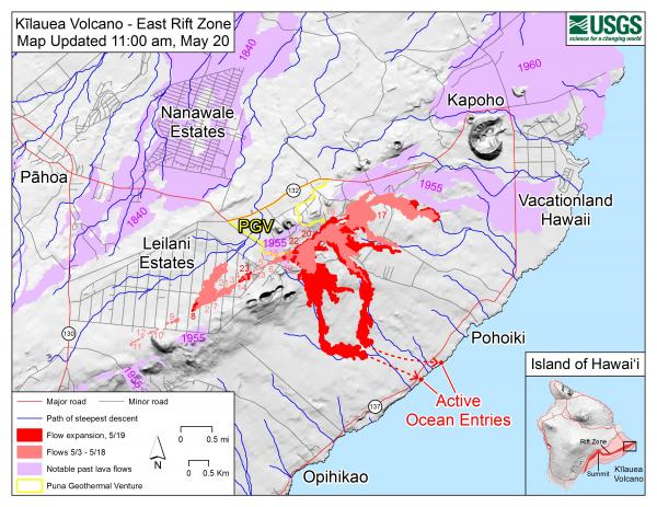
The map at the top shows the elevation. Mauna Loa is the elongated elephant. Kilauea is the bump just below it, on its flank. The site of Pu’u’O’o is indicated by the red arrow. The east rift is clearly seen. Mauna Loa is known for its long rift. But Kilauea is not bad either! This volcano is not just a pretty summit. It too has a long reach. Before 1950, summit eruptions were the norm. Since 1950, the summit has done rather little and eruptions have tended to come from the east rift, dominated of course by Pu’u’O’. The entire east rift is a staggering 125 km long, over half of which is beyond Puna in the ocean. The part between Pu’o’O’o and the tip of Puna, Cape Kumuhaki, is sometimes called the Lower East Rift Zone, or LERZ for short.
The LERZ is a little over 20 kilometers long and a few kilometres wide. It forms quite a pronounced ridge, slowly declining in elevation from over 500 meters near Pu’u’O’o to sea level at the coast (admittedly this states the obvious). The ridge stands 50 to 150 meters over the surroundings, and is built by spatter from the many eruptions. Individual cones may be as high as 60 meters. On the southern side the slope is much steeper than on the north: this is caused by the tendency of the south side to slip towards the sea, as also happened earlier this month. Lava goes either northeast or south/southeast, depending on exactly where on the ridge it originates. It is often a close call. Most of the eruptions have been from long rifts similar to the current one. The rifts tend to form a line of rift segments rather a single rift. The segments are not entirely aligned: they tend to show sidesteps, 10-100 meter sideways. Rifts on the northern part of the ridge tend step towards the left, and ones on the southern side step to the right, in both cases diverging a bit from the ridge further along the LERZ. However, towards the eastern end, the southern rifts can become left stepping, towards the north. There are other types of eruptions. There is one large shield (Heiheiahulu), very similar to what Pu’u’O’o has done and in fact not very from that location, covering the area directly to the coast. There is also one explosive crater, 1-km wide Kapoho. It is only just above sea level, and so it is likely that the explosion was caused by sea water intruding into the rift. This was not a minor event: an area of 6 km2 was covered by its pyroclastic flows.
Let’s look at some of the more recent eruptions. Historical events began with the 1790 eruption, although there are oral stories among the Hawaiian of older eruptions.
The 1790 eruption was one of the defining outbursts of Kilauea, with deadly pyroclastic explosions at the summit. But the eruption also involved the LERZ where it was a major event. It formed not one but two rifts, 1-2 km apart, one on the southern side and one on the north. The southern rift was over 8 km long and the northern one a massive 13 km; both are segmented (‘echelon’) with side stepping. The flows cover 35 km2 and the volume in the LERZ area is about 0.12 km3. The crater of Kilauea may have formed in the 1790 eruption, but only a small fraction of the evacuated magma has come out in the LERZ.

Lava from the 1790 eruption. Source: Bull Volcanol (1992) 54:475-483
The next major eruption was in 1840. It erupted from a northern rift, 7.5 km long, with a couple of vents about 1 kilometer further north, somewhat away from the ridge. The lava flowed northeast-ward and covered some 20 km2. Where it reached the ocean, a cone formed, build by explosions as the lava hit the water. The total volume of the lava was around 0.15 km3.
The 1955 eruption, described in the previous post, came from a southern rift, 16-km long which included a 2.5-km gap which did not erupt – which is where the 2018 eruption is occurring. It was slightly smaller than the 1840 eruption, covering 16 km2 with 0.11 km3 of lava. It reached the ocean in two areas.
Sofar, the 2018 eruptions have covered 1.3 km2. The volume is still less than 0.01 km3. We are still very far from 1790 territory!

The 1960 eruption came from a short segment, 1-km long, at Kapoho which was where the 1955 eruption had terminated. It followed on from an eruption at Iki, and like the current eruption, the rift eruption was accompanied by deflation at Kilauea. The lava covered 10km2 and amounted to 0.12 km3.
There was a short eruption in 1961, which covered about 1 km2 in the western part of the LERZ and lasted one day. And nothing since. There were three eruptions in 7 years, but nothing for 115 year before, and nothing after until now, a gap of 57 years! The frequency of eruptions in the Puna area seems slightly irregular. The south side of the ridge had no lava flows for 165 years. No wonder people felt safe. The period 1955-1961 seemed the exception, and the time since, the rule. Of course, Leilani was built on the ridge itself so it had twice the risk – but twice a very small chance still seems a very small risk (of course people who play the lottery think exactly the opposite: the potential reward skews the perception of chance.) 20% of Puna was covered in lava flows less than 250 years old, but most of that happened 200 years ago. That was a different age, wasn’t it?
But history tends to repeat itself. What does the older history have to say? What was the real risk of building in Puna?

Puna’s past
All of Puna is lava. The lush growth conceals this well but look underneath and even the rain forest is built on lava. In this climate, it doesn’t take long for lava to green. The first plants germinate within months (although the heat on the black lava can be pretty hostile until some shade develops) . Trees can grow on 40-year old lava, and after that, only the height of the trees betrays the youth of the lava.

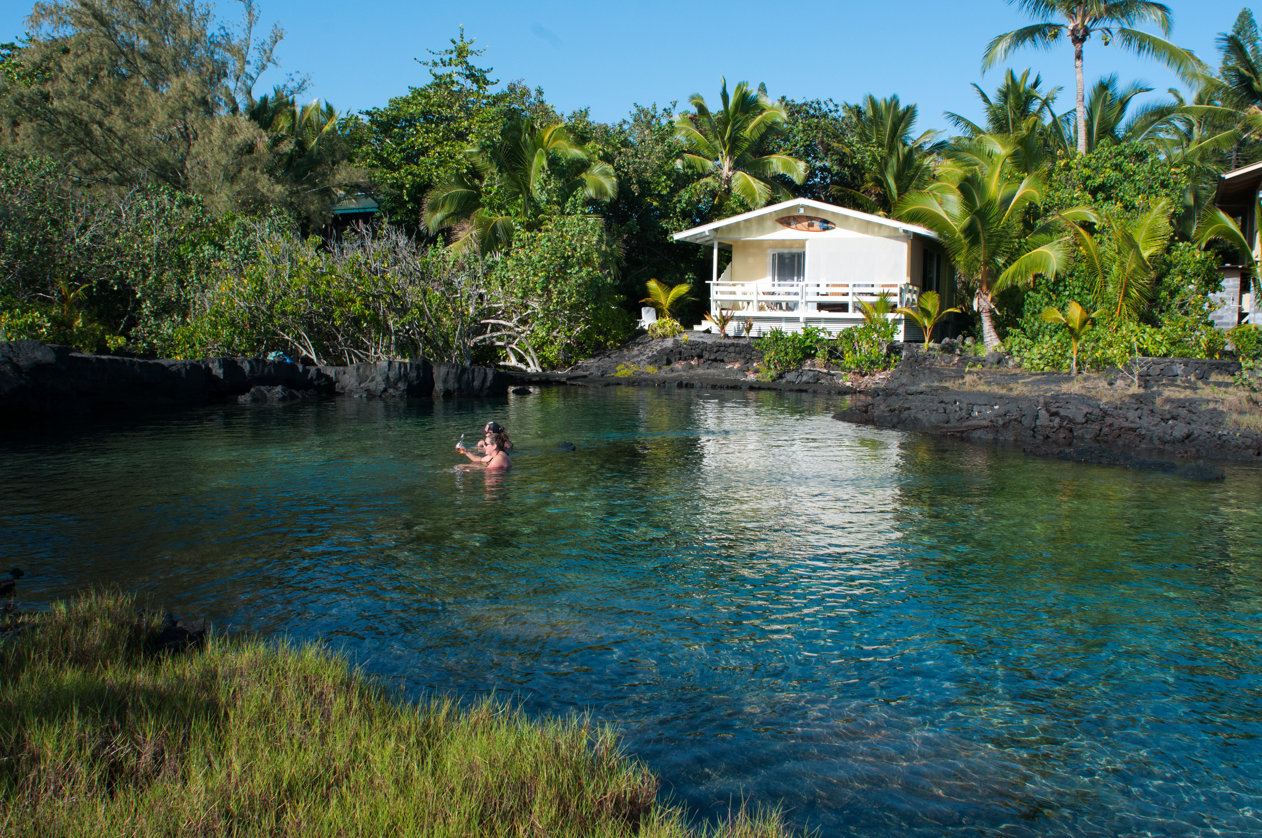
Sprouting coconut trees . Photo by Donal McGowan
Carbon dating has been applied to many of the lava flows here, and this has shown a surprising picture. It seems that the past 250 years have been a bit of an anomaly.
Before 1790
Let’s go back a little more. A total of 15 different eruptions are dated to the 200-year period before the 1790 eruption. This includes the explosion of the Kapoho cone. It also contains the shield of Heiheiahulu, which covers a surface area of 45 km2. That eruption started as a short fissure, before building a large cone which at the end collapsed and became a pit crater. Heiheiahulu is very much like Pu’u’U’o. Local stories suggest that it erupted somewhere between 1700 and 1750, and if it is indeed a Pu’u’O’o copy, it may have lasted years. The volume is probably of order 1 km3, which is a few times less than Pu’u’O’o.
Also interesting is a flow from Ai-laau, a vent to the northwest of Kilauea. This produced a flow which made it to Puna, covering the region northwest of the ridge. The flow cover 100 km2: the summit still can outcompete the rift! It also shows another truth about Puna: while the southern and northeastern part are at risk from the LERZ, the area north of the rift is affected by eruptions from near the summit of Kilauea. This is another eruption mode we haven’t seen for some time, but it will re-occur – eventually.
Including these three, a total of 15 separate events have been identified for this period of time. In total they cover 50% of Puna. Ai-laau and Heiheiahulu are by far the most voluminous: excluding them, the rest amounts to about 1 km3. Clearly, the 200 years before 1790 was a scary time in Puna.
Before 1600
Going back another 250 years, eruptions become even more frequent. In the time period which runs roughly from 1300 to 1600, at least 20% of the area of Puna was resurfaced. It may have been much more, since the later flows will have covered up much of the evidence. A staggering number of 54 eruptions have been identified in this time zone. For about half we know where they came from, as we have found the spatter cones at the origins. For the others, the point of origin is buried under younger flows. The eruption of the spatter cone of Puu Kaliu came from a fissure about 1.5 km long, along the southern side of the LERZ. It covers at least 12 km2, and the volume is about 0.2 km3. Puu Kaliu is just south of Leilani.

Two other eruptions were of similar size. One is dated to 490 BP (with an uncertainty of 60 years either way) and lies on top of the Puu Kaliu flows: it covered at least 18 km2 and has a similar volume to Puu Kaliu. The second is dated to 440 BP and may have formed a shield similar to Heiheiahulu, but it is mostly buried by the latter and by the 1955 lava. The cliffs at Kehena, with at least 15 separate layers, comes from this eruption. Puulena Crater is another event from this time period. It is the site of a major phreatic explosion, possibly when a rift opened underneath a lake.
So this was another exciting period of time. Going back further, the record becomes more and more patchy as the evidence for the eruptions is buried underneath younger flows.
When Pele wants to play
So what can we learn from this? Some caution is required as not all dates may be that accurate. Also, some eruptions may have been double counted. For instance, the distinct flow fields of the 1955 eruption could have been counted as two different eruptions with these methods. But overall, it appears that the eruption frequency at Puna has been much higher between 250 and 800 years ago than it has been since. It also seems that the long duration of the Pu’u’O’o eruption is not that exceptional. There have been other longer-lived rift eruptions in the past.
Since 1790, the LERZ has erupted on average once every 50 years, although the intervals have been highly variable. Before that, the eruption frequency was closer to once every decade. And even though the individual volumes aren’t huge, peaking at 0.1-0.2 km3 with most eruptions considerably smaller, at this frequency Puna was rather quickly covered in lava. Almost the entire surface is less than 800 years old. Build a house anywhere in Puna, and the risk of losing it to lava is of order 20% per century. Build it on the ridge, and that risk doubles. Kapoho, at the coast, is particularly endangered: there have been a lot of eruptions in that area, and it runs pyroclastic risks when sea water penetrates the rifts.
The average dormancy time of the LERZ over the past millennium is only about 15 years. Puna is not just a distant appendix of Kilauea. Pele loves it out here, and many of Kilauea’s eruptions push into this region. The volume may be limited, but Puna is one of the most volcanically active areas in the world and possibly the most active in Hawaii. The past 200 years were exceptional. The current eruption is business as usual. These lush gardens are built on a regular supply of molten rock. There is always a cost to paradise.
Albert, May 2018

This post is based on the paper Volcanic geology and eruption frequency, lower east rift zone of Kilauea volcano, Hawaii by Richard B Moore , Bull Volcanol (1992) 54:475-483
Kilauea update 21 May
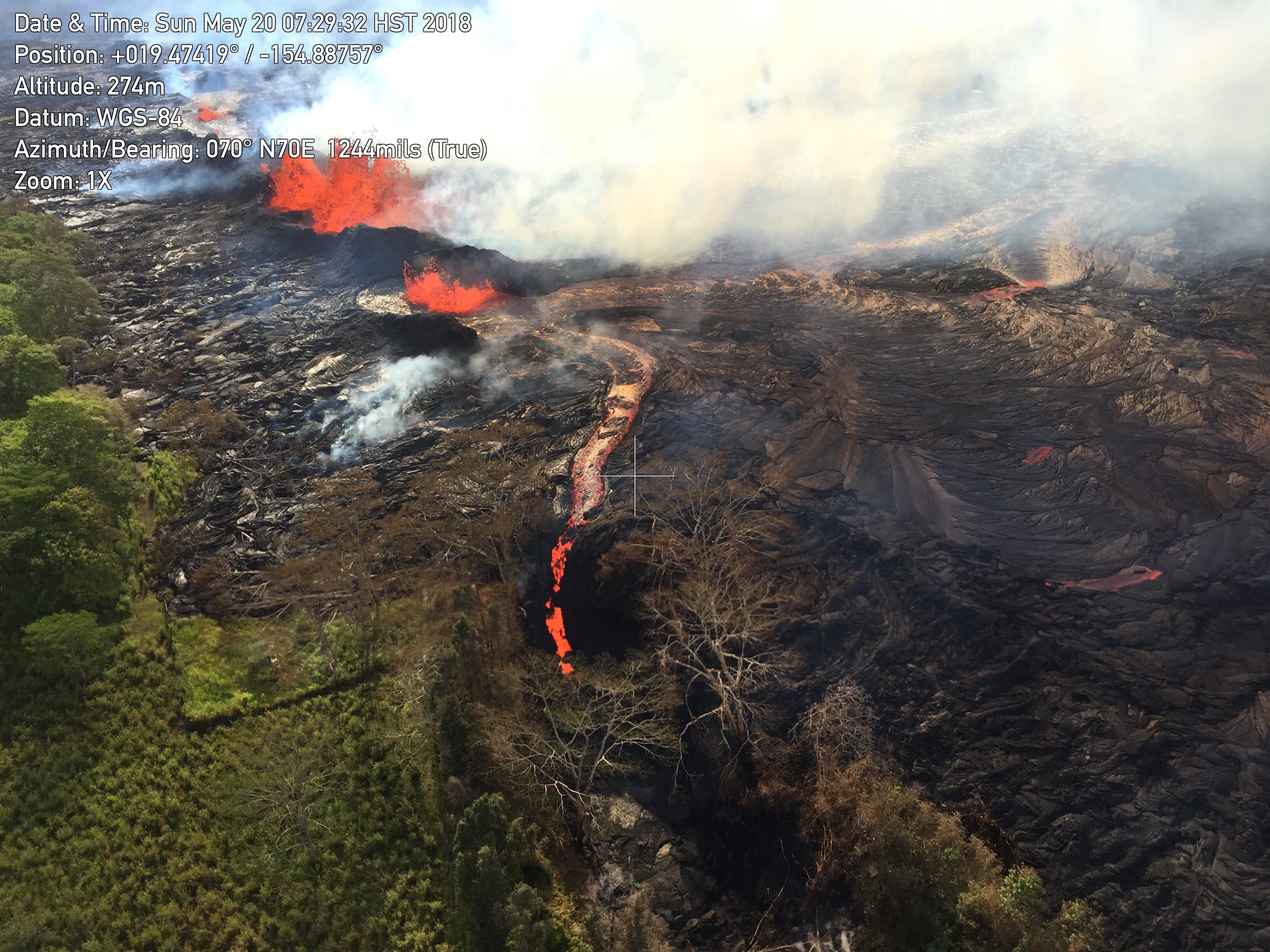
In the past few days the eruption has gone into another gear. Before, the lava was sluggish and build a ridge but had difficult going beyond that. But, as HVO has predicted, once the new lava arrived it was obvious. Fountaining was the first sign, and soon lava not just clogged but positively flowed. Lava rivers appeared and they moved fast.

A river flows through it..
The activity became confined mostly to the east-most end of the previously numbered fissures. Fissures 16 and 20 merged and became the main point of action. Fissure 17 came along but seems to fissing out. The map below is on a google map viewer. It shows that the action is just below the Puna Geothermal Plant, which presumably is now defunct. Interestingly, this plant was put in this location because of a thermal anomaly: the ground underneath had higher heat flow than other locations in the area. In hindsight, was this a warning? It is also the area that hadn’t erupted in 1955 while the ridge on either side (of Leilani) had. Now we known that the magma hadn’t skipped through: it had been stored here for later use.

A map of the active fissure and flows, as of 12 hours ago.
An estimate from the map suggests that the total flow field covers 2-3 km2 so far. A large Puna eruption tends to cover some 10 km2. We are not in that range yet. The amount of erupted lava may be around 0.01-0.02 km3. The current flow field may not get that much larger in surface area until the eruption moves to new fissures.
The fissures have fed two lobes, one of which moved though housing and farm land, and the other through rain forest. The two lobes met and split again, flowing around a kipuka and fed two ocean entries. The eastern (farmland) than found a crack and disappeared into it. What happens next depends on how big a hole it has found, but lack of steam away from it suggest it has not gone far.
Obviously, where lava enters the sea you will get steam: with this volume the lava itself actually become hard to see. The white cloud is both impressive and extremely dangerous. It contains hydrochlorid acid and minute glass particles – think asbestos. Some of the videos taken from boats look dangerously close to the plume to me. (There is a 300 meter exclusion zone which they will be obeying.) Luckily, the trade winds are blowing the plume along the coast away from people on-land (the ones still there shouldn’t be). By the weekend the winds may change and blow the plume in-land, but again, hardly anyone is left there. Along the fissure, the SO2 is very bothersome and it is unlikely to get any better. Volcanic smog is awful and a considerable health hazard.
Fissure 17 (at the far end) is now reported to have erupted andesite. That is probably not that unusual. Puna has significant magma storage and depths of 1 to a few kilometer, and some of that evolved magma has come up. Fissure 17 is at the end of the current line of activity, and so the magma it produced may have had the least amount of mixing with the new magma. There was some discussion whether it came from 1955, but there is certainly far older magma around.
What is next? The current fissures seem to be less vigorous than before and they may have peaked. Cinder cones have build up which I estimate at 30-40 meters tall: some will survive. Fissure 17 will cease shortly, I expect. HVO has reported that GPS no longer shows expansion of the rift, and so the inflow no longer exceeds the outflow – at least here. The fact that the earthquakes around Leilani have ceased also points at that. However, if the current fissures become less active, the pressure up-rift will increase and this could well lead to eruptions there. Fissure 21 is particularly worth watching. Over the next week, there is a danger of similarly fluid eruptions within Leilani, and later also further west. However, this is far from certain! Everthing south of the fissure line is at risk. Outbreaks west of Leilani could also flow northward, although it is unusual for Puna eruptions of the same rift to go both ways.
Pu’u’O’o is dead. GPS shows that the exponential decline has bottomed out: there is nothing left there to drain. It seems unlikely to ever recover, and its final fate may be that of a collapsed pit crater. But who knows, it could still surprise us in a few months.

Halemaumau has settled in a pattern: it shows increasing tremor, explodes, tremor goes away but slowly rebuilds. It is not clear to me what causes the tremor: I was wondering about boiling water.The crater size expands with the explosion but the rock quickly recovers and resumes its contraction. There tend to be a few explosions at the same minimum crater size, after which it goes to the next size. The explosions are not as strong as earlier, but this means nothing. These explosions could continue for quite some time, until the lava has risen again to above the water table. The park could be closed for some time.

I have not seen any estimates of the damage yet, apart from a few million dollars due to tourists staying away (can’t entirely blame them, but the north side of the Bg Island is also spectacularly pretty and far from any volcanic disturbance!). But in the scheme of things, that will be small fry. To compare: the Kilauea eruption of Feb 28, 1955 destroyed 21 houses, 10km of road, 4000 acres of sugar plantations and one coffee plantation, amounting to 40 million dollar at today’s prices. Mt St Helens cost 1 billion US, which is half the price of Eyjafjallajokull where the dominant cost was the continent-wide flight ban. The mud volcano in Indonesia has cost around 3 billion so far. The 2018 eruption has already destroyed more buildings than in 1955. However, most of the 1955 cost was in the lost sugar, while in the modern economy there is much less value in the land and much more in property. We can estimate that Leilani as a whole is worth 200 million US, and the geothermal plant probably around 100 million, based on its 38MW capacity. (I find it amazing that Leilani was started less than a decade after the 1955 eruption!). Double the cost to include clean-up, road rebuilding etc, and one can guess a total cost of around half a billion US. That assumes that this eruption continues for a few more weeks: if it ends soon the cost will be less.


And finally what we’ve all been waiting for…
Here’s Rusty!
Rusty doesn’t flinch after the explosions. He’s one tough rooster.
Nice, his camouflage matches the rocks.
And the comb like fissure #20 (concidence?)
“Nice, his camouflage matches the rocks.”
“And the comb like fissure #20 (concidence?)”
🙂
Yes, coincidence. Structurally, most have combs not unlike that.
What happened to the images on the front page? And why has Fissure 17 reverted to Strombolian spattering, while Fissure 20 continues to spew more fluid, juvenile magma?
Probably because fissure 17 is dying slowly, which is why its lava flow didn’t really reactivate with the new magma and is instead building a big cinder cone. Fissure 20 is the main vent now I guess.
The tree near 17 is suffering from an identity crisis and doesn’t want to be there. He is called ‘Piney’ because it’s a bit like Pliny who gave his life heroically trying to rescue a friend when Vesuvius erupted, but he now realises that Pliny was an elder, not a pine. So now he’s pineying for the fjords.
(I am so sorry for that drivel)
For those that don’t know… Pliny the younger wrote it all down. From his texts we have the term “plinian” eruption from his description of the 79AD eruption of Vesuvius. As noted, Pliny the elder didn’t make it. This was due to either a cardiac event or gas inhalation. He had been trying to rescue people from the shore with his ships. At around 55 or 56, he was well aged for the time period and probably was more susceptible to noxious gas. (and has been described as corpulent… with asthma.) → Note the warnings currently being given out by emergency operations personnel in Hawaii regarding VOG and people with breathing problems.
“The wind caused by the sixth and largest pyroclastic surge of the volcano’s eruption did not allow his ship to leave port, and Pliny probably died during that event.”
“His companions theorized that he collapsed and died through inhaling poisonous gases emitted from the volcano. On their return three days later (26 August) after the plume had dispersed, his body was found under the pumice with no apparent external injuries.“
Pliny the Elder
… A hard piece of translation to be done at school….
The ocean entry plume is building big time –> https://www.facebook.com/johnkaponocarter/videos/2039949342883439/?t=129
Like a Turner painting
“The plume is an irritating mixture of hydrochloric acid gas (HCl), steam, and tiny volcanic glass particles. This hot, corrosive gas mixture caused two deaths immediately adjacent to the coastal entry point in 2000, when seawater washed across recent and active lava flows.”
https://volcanoes.usgs.gov/observatories/hvo/hvo_gas.html
Last map
Photos, I think from yesterday.
GL Edit: [Photo Links removed. They yielded “
Bad URL date param” responses from the server. Generally, if the link does not end in “jpg, png, gif” or some common image format, WP will barf on them.]Civil Beat live:
Please try and avoid multiple links in a single comment, it’s sends our spam filter into overdrive.
Just now a other event at Kilauea summit
Electronic tilt Kilauea Summit.
Source :https://volcanoes.usgs.gov/volcanoes/kilauea/monitoring_deformation.html
Based on that plot, I get a return interval of between 6 hours 18 minutes to 15 hours 19 minutes at the 95% conf interval… If the spikes correlate to summit events. (explosions)
Note: Your mileage may vary, Objects in mirror may be closer than they appear…
That should be this one
3.1 8km W of Volcano, Hawaii 2018-05-20 21:52:29 (UTC) 1.6 km
Source USGS
Hmmm – that’s a bit far away and isn’t listed as an explosion (chemical or otherwise).
But what is this a couple of minutes earlier.
And Byron’s Ledge
And here’s what was seen at Mona Loa
Mauna Loa!
Also on WILD at Mauna Loa
Nope it is this much delayed one
https://earthquake.usgs.gov/earthquakes/eventpage/hv70167521#executive
M 4.9 Volcanic Explosion – 5km WSW of Volcano, Hawaii
Time
2018-05-20 21:50:07 (UTC)
Location
19.405°N 155.281°W
Depth
0.0 km
“This event is a steam-driven explosion that occurred around 11:50 AM Sunday May 20th local time from Halema’uma’u crater. The plume extended to about 10,000 ft above sea level and drifted southwest with possible ashfall at downwind locations”
Pushing the exit button didn’t help Albert! 😮 😉
Events just keep coming from this eruption. Have just seen this posted on SM from a very reliable –> “The easternmost flow coming out of fissure 20 had a hole open up and all the lava is pouring into it! “The hole opened up and the entire width of the channel and all of the lava that was flowing toward the east from the fissure 20 complex is pouring down into this hole in the ground”
That doesn’t sound good at all.
Well…that eastern flow was the one which wasn’t heading toward the coast in a hurry, so the clastal entries should be fine. Now–what is this hole/crack? Probably a lava tube from days gone by, the weight of the lava, or the thermal shock, or earthquakes caused it to unroof. Less likely is that a pit crater decided to take this moment to open up. So where will the lava go?
Before the crack opened, the lava had been flowing in a channel. Could it just be a crack in the lava, itself, so the lava is now flowing within / under the lava flow?
Is that the hole that formed yesterday? That was pointed out by Demian Barrios on the Civil Beat live stream? There was a mound or a cone and suddenly it collapsed, leaving a crater…
Dont think so, here is copy and paste of the post made by the page owner of Hawaii Tracker on facebook. (It has todate been extremely reliable source of information for locals in Puna. “Sunday Afternoon Update 12 noon HST
Chain of Craters road could take 4 weeks to open.
Just got off the conference call with USGS and NOAA and here are some interesting bits of information that I came away with.
More fissures have begun opening back up in Leilani Estates. This needs to be noted because in the 1955 flow that this current flow seems to be mirroring, the fissures trended uprift, towards the top of Leilani and even further. All indications at this point are this current flow will do the same. I believe it’s just a matter of time.
The easternmost flow coming out of fissure 20 had a hole open up and all the lava is pouring into it! “The hole opened up and the entire width of the channel and all of the lava that was flowing toward the east from the fissure 20 complex is pouring down into this hole in the ground”
They have no idea where it is going or if it will be seen again. The last time this happened (2012?) the lava was never seen again.
The western most flow is continuing to pour into the ocean and is the most vigorous.
Chain of craters emergency road is a minimum of 2-4 weeks out before possibly completion. NPS, state, federal agencies do not even have an agreement ironed out yet but hope to have one later this week. I repeat, 2-4 weeks out minimum for completion of the road being opened up. If you are a resident that relies on highway 130, you need to take this information to heart when making an informed decision about what you should do. There is a very real possibility that 130 could be closed again before that time.
Weather, dryer conditions starting Monday. Trades will continue their normal path. Ash emissions from Kilauea will go to the SW.
Under current weather conditions and gas levels by the ocean entry, laze is traveling downwind for 15 miles. If it stings, go inside.
Friend to friend. 130 could be cut off in a week. Lava is trending upward again higher into Leilani. 1955 flow did the exact same thing, like a roadmap for us. People need to plan for 130 to be closed in as little as a week in my opinion. This has all the makings of a catastrophe if that happens before the road to the national park is opened. Sorry to be blunt, but these last second emergency evacuations and animals being left behind situations are unacceptable given the amount of knowledge we currently have.”
As of yesterday, lava was flowing south from fissure 20. From HVO’s alert on Saturday afternoon (Hawaii time):
“Beginning yesterday and into today, the rate of lava eruption has increased. Fissure 17 is weakly active now, and Fissures 16-20 have merged into a continuous line of spatter and fountaining. Flows from the consolidated Fissure 20 crossed upper Pohoiki road late yesterday afternoon and continued flowing southward. This afternoon two flows from the merged fissure complex have joined less than a mile from the coast and continue to flow southward between Pohoiki and Opihikao Rds. The lava flow from Fissure 18 is stalled. It is unknown whether the flows will continue to advance, or stop, and new lava flows are likely given the rate of activity seen at the rift zone. Volcanic gas emissions remain very high.”
Source: https://volcanoes.usgs.gov/volcanoes/kilauea/status.html
Be interesting to see today’s alert.
Lava from fissure 20 made it to the ocean. Image today from US Geological Survey
I mean, it’s probably fine, but that does somewhat sound rather alarming, in the british meaning of the term.
Is there a link for this? I can’t see any reference on HVO or Hawaii News sites.
Found it on USGS:
I found the video footage where Demian Barrios points out the hole that formed. Wait like 30 seconds till they pan the cam towards it, a bit later on… https://youtu.be/SN4ai47iNOE?t=3h51m14s
Ah so it was the same thing, my bad! There was some footage of the lava waterfall into the “hole” on FB earlier today but the uploader has since removed it. Unsure why…
HVO has confirmed that the lave from the eastern flow has been diverted underground.
So I look at this picture and I think about several things.
The houses in the background are still standing but the plants are all dead.
The depth and width of the now abandoned lava channel is significant.
All that lava is going somewhere…but where? Farther down the rift zone but will it emerge again?
Now that the lava is back underground does that make it magma again? 😊
It happened at least once during Mauna Ulu. the lava reappeared somewhere east of Napau but not too many details. Accounts vary as to whether the lower vent of Mauna Loa 1935 was due to lava disappearing into an old pit crater, lava tube skylight, or whether it was a radial fissure eruption.
Gordy, I wondered the same question — is it still lava, or is it back to being magma?
Also I’m curious — if the now de-gassed lava / magma stays below and cools, what neat crystals will be formed? (I am finally getting around to trying to learn some chemistry and basic geology.)
Depends on how quickly it cools! If there are lots of holes (gas-rich magma) and good insulation (very slow cooling) you could get impressive crystals.
Big or small, I think you would get olivine (or olivine group minerals) crystallizing out first. One reason you get olivine cumulate layers in large basaltic sills (e.g., Pallisades sill in NY). However, not familiar with Hawaiian lava crystallization sequence and would be happy to be corrected.
Crystallisation sequence in basalt is pretty standard olivine – pyroxene -feldspar Often, Hawai’ian lavas at the point of eruption already have visible green olivines present, their melting point is higher than the lava temperature There are research results (probably available online, but I haven’t got time right now to search) from experimental drilling into the deep Kilauea Iki lava pond (1959?) -passively filled from fissures higher upslope- which give a pretty good chart of the sequence By the time the lava was more than half solidified, the residual liquid/glass had a silica content of around 60%, that is, andesite
Solid Solution Series.
http://csmgeo.csm.jmu.edu/geollab/Fichter/IgnRx/SolidSol.html
Also note, that when a material reaches it’s liquidous point, it takes a little extra omph in energy to push it back into actually melting.
“For example, when melting 1 kg of ice (at 0°C under a wide range of pressures), 333.55 kJ of energy is absorbed with no temperature change. The heat of solidification (when a substance changes from liquid to solid) is equal and opposite.”
Reading that fissure 17 is producing andesite lava shortly after reading about this lava diverting back underground, it seems probable (to me) that this “lava goes back under and waits” thing has happened before in this area. …
I haven’t read the Andesite thing. Got a source link? (article or paper)
I know some group came out and said #17 magma was something not seen in Hawaii before, but the article didn’t say much other than that the lab receives FedEx packages and crushes rock.
This could be the “recent research” that was alluded to in the USGS video that said Kilauea tends to have more explosive eruptions in its history over the last 2500 years.
For all; Until I have a verified source, this is just idle conversation between random posters. Also, Andesite is not a full on oddity, it’s just an end product of long stay time in a magma chamber or mixing with continental crust.
I am reminded of the argument that scientists at El Hierro were having with a University in Spain over the composition of the “Floaters” produced by Bob. Whole rock analysis showed Rhyolite, but if you looked at the structure of the floaters, it was clearly basalt mixed with a high silica material. (likely from melting the Jurassic era phyllite that formed from sediment in a basin when the Atlantic was just a place for water to collect. Phyllite is a metamorphic rock intermediate between shale and schist. All of the Canaries are built on top of this layer)
The issue is that the higher the silica content, the more “explosive” the magma is. High silica magma is stickier and retains gas longer. Suddenly release the pressure and all that gas tries to come out of solution at a fast rate. {The source of the lateral blast of Mt St Helens after the landslide exposed the magma pocket}
Oh, and I’d been wondering why the vast majority of steam explosions in the last few days of this event have been from the non-lava-producing side of fissure 17. I’m sure the andesite thing is part of the reason — either that or fissure 17 coincidentally has 2 features that are different from the rest.
I can’t help but wonder about the mechanics of how that works.
(This type of curiosity is why I keep trying to learn chemistry — a subject that has never held an interest for me — so that I can progress in learning geology. I want to know how everything I see in the landscape came to be that way …)
This news fits in with that article the other day about the firm in NY analyzing the lava and something about fissure 17 being different.
https://www.facebook.com/cheryl.gansecki/posts/10212005545839964?hc_location=ufi
I think that was the “we crush rocks” people. I don’t do faceberk, so I can’t read whatever they had to say.
Closer to the original source (USGS) but I couldn’t find the actual comment on their FB page. (I didn’t feel like opening up all the comments and reading them!)
In case the twitter shows up wrong, the quote is:
“Unusual chemistry: “flow from Fissure 17 is andesite, unusual for Kilauea, suggesting magma has been sitting in rift for long time. Different than earlier samples, attributed to 1955 magma. Possible magma feeding 17 has been in rift since 1924. (USGS Volcanoes Facebook comment)”
https://twitter.com/CPPGeophysics/status/998415979003572224
That will do it. Thanks!
That also might be the explanation for the explosive nature of some events on the eastern rift that they were alluding to in the geologic past.
FB poster is Cheryl Gansecki, geologist living in Hawaii, owner of a video place who took some video maybe yesterday ‘while working for USGS”. She simply says it is erupting andesite but says more in the comments.
Well, Andesite would be expected for long stored magma. Not as problematic as Rhyolite, but still more viscous than Basalt.
I have a feeling that this has something to do with the dacite found at depth in the geothermal well when they were drilling. Is the whole flow from fissure 17 made of andesite?
Maybe there are andesitic rocks in some other eruptions too and they get buried under later products. Depending on how long this eruption goes for maybe fissure 17 will eventually get entirely buried too.
I did notice the pretty uncanny similarity between the lava from fissure 17 and the lava erupted at shinmoedake in January, which was undoubtedly andesitic. In the event that andesitic magma was to erupt further up the rift (maybe in the pu’u o’o area in 50-100 years) and a flow went south, I wonder if it would create pyroclastic flows by collapsing down the steep slopes there? That would be quite a sight for Hawaii…
The interesting part with this is that the hole is in like with the erupting vents, so the part below there must have been shut off and left a void. Maybe it is just a pit and when it fills up again the lava will reoccupy the drained channel?
Here is a video of everything that is going on right now. its from the morning but still relevant as nothing has really changed at fissure 20 since then.
Btw., the video still shows fissure 6 still pretty active. Compare with the google earth satellite image (location is slightly right from the center. You can also see the PGV on the l.h.s.):
https://www.openstreetmap.org/#map=17/19.47134/-154.89130
Here is the video still I mentioned:
This is a video of how pahoehoe flows work. Keep in mind that the episode that happened at Kalapana was fed from a very consistent supply of lava for a long period of time. Let us hope that does not happen with this current eruption. There is a very informative graphic at the end of the video that shows where the lava flows have happened in the last 1000 years or so.
Looking at the last graphic I’m thinking that one would have a good chance at living out their lifetime in a piece of paradise, and watching their grandchildren grow up in the same place. Just be aware of what could happen. It seems like many were aware and accepted the consequences of what could happen, but a few just didn’t have a clue. I have a hard time finding any pity for those that didn’t have a clue, due diligence, but I have great empathy for those that knew and understood the place that they chose to call home.
https://www.youtube.com/watch?v=Ooes_mqTwME
Volcano Video Hawaii
Published on Oct 27, 2014
SUBSCRIBE 53K
This video was produced by Dr. Cheryl Gansecki of Volcano Video Productions in cooperation with Hawaii County Civil Defense to show residents how pahoehoe lava flows work.
excellent! A+++ a lot of flow info…. Best!motsfo
Woo Hoo!! I got an A++ from motsfo. That made my month. Thank you.
Well You earned it! Best!motsfo
Absolutely! Thank you.
https://www.google.com/maps/d/u/0/viewer?mid=11tCiLa42FId7GMtg-4UkEoAI9QozTVFD&ll=19.47963489494244%2C-154.9261877402115&z=12
This map has updated to show the full flow now. All it took was one day to go from a tiny line of spatter cones up to a serious flow field… The 1955 kii lava flow actually looks small against it now compared to only a few days ago. I think the majority (like 80%) of the flow is going out the other side of fissure 20 from where the livestream house is, ight into the ocean. The vents feeding the eastern flow going into the hole are much smaller than the ones a bit further back by the looks of it.
So the Isaac Hale park and the boat ramp have a chance. From what I have seen on Google Earth that is the only boat ramp for a long ways. Boat ramps are an important thing.
I like that map.
not to imply any impending doom but wasn’t the ‘boat ramp’ of Pompeii filled with people who couldn’t get on the boats?? (motsfo rummages around in the attic of her mind)
Yeah, I think so. Pliny the Elder got stuck down in Stabiae by the prevailing winds and couldn’t easily tack back up the coast to get them.
(I don’t even know if the Romans knew how to tack)
Kind of hard to reconcile them not knowing how to tack with their success at controlling the Med. This was probably within their nautical skill-set.
not until about 50BC apparently https://quatr.us/romans/roman-sailing-boats-roman-empire.htm
but that means yes the could tack by 79AD for pliny
Probably not. The Lateen sail that made tacking possible, started to be used in the Mediterranean some 1000 years later (It was developed and used by the Arabs, although it is argued the Greeks used brailed sails, which use a similar design but are rather rolled in a particular way, and the Romans adopted them later on, although no conclusive evidence has ever been found they were widely used before the 3rd-4th century AD. Adaption to new techniques often was slow in these days). The Roman merchant fleet used rowers and sails, and the oars and rowing techniques used were mainly for crossing large volumes of water – unlike the military vessels that used techniques to more easily manoeuver. In winter, there was a 4 month break in trade on the Mediterranean due to prevailing winds that made sailing nearly impossible…
Roman merchant ship. Image source: http://bertan.gipuzkoakultura.net/23/ing/5.php
The buildings by the docks in Herculaneum were filled with people who didn’t escape. The folks in Pompeii were struck down all over the city, but Herculaneum’s streets were empty For decades it was assumed that the people had time to escape, but they only had time to congregate at the docks. Perhaps some made it on to boats, but I am not aware of any survivor accounts regarding that scenario. Someone who knows the literature might be able to enlighted. I just have a Nova-National Geo-Scientific American perspective on the research.
Wow it looks like one of the fountains just a bit off screen on the livestream is getting bigger now. Its still part of fissure 20 but it looks like it is getting a lot bigger than the ones in the center of the view. I dont think it is really high and changes a lot but I dont remember seeing any fountain there before so this could be interesting.
It might be the small fountain in the middle of this picture:
I wonder if it filled in that big pit yet, it doesnt look like there is any actual hole there so I think it is just a depression which is filling with a lava pond.
Earthquake activity in Leilani seems to have ended. That suggest that the magma now flows unimpeded: the fissures can cope with the flow rate. It seems unlikely now that there will be migration down-rift, but as activity wanes it is more likely than not that there will be migration up-rift.
It seems like the eruption rate is increasing again too. One of the fountains at fissure 20 is huge now. The other ones are smaller than before but the big one has gotten more than big enough to compensate for that. I wonder if there will be really high fountaining in the next day or two. That would fit with the 1955 and 1960 eruptions, and also with 1959, 1969, 1977 and 1983… This could be bad news for leilani as it would really change topography and rootless lava flows could flow north. Would create a pretty massive flow into the ocean too, well more than it already is anyway…
It is possible: as the magma temperature increases (less mixing with the old magma) fountains could invigorate. The southwest parts of Leilani are probably a lost cause. Any flow to the north would be devastating but lava does not like up-hill so it would only do so from some of the fissures. I was surprised to see on the images of the lava river how many houses and farms there still were south of Leilani. The google maps has suggested less housing.
I guess maybe a lot of people wanted to live in hawaii to see the nice little lava flows from pu’u o’o, the sort of stuff you actually can just walk away from. I think puna was also very cheap land up to about 5 years ago so lots of people went there probably not knowing that eruptions had happened there within living memory (especially because a lot of the vents had been quarried or deliberately planted over with trees). Im surprised google earth hasnt updated that area more recently with all the satellite pictures of pu’u o’o and the June 27 flow, and with it being an American state…
The still existing default picture of pu’u o’o is from January 2013 when the kahualea 1 flow had just started. It shows the terrain north of pu’u o’o as it had been since the 1980s, with old a’a flows that were starting to regrow trees. Now it is a grey barren plain covered in pahoehoe that extends about twice as far north. The topographical change there actually means flows erupting on the northern side of pu’u o’o will go into northern puna towards inhabited areas now, so effectively the ridge of the east rift starts at pu’u o’o and goes east from there now. The lava hazard zone of the area north of the east rift will have to be redrawn now, with much more of the north being at risk than before.
I wonder if that hole has been filled in yet. The vents feeding that part of the flow had gotten a lot smaller before the camera was turned to the right, so maybe that whole channel is now inactive entirely and the lava goes down the other channel. That big fountain must be causing the channel to overflow a lot now, the maps will be changing a lot tomorrow.
According to USGS, the lava will recycle and leak out nearby.
For unclear reasons, all your comments end up in the decontamination unit. A more senior admin will need to investigate. – A junior admin
If the lava flows into an active vent then why doesnt lava just erupt directly out of the hole? I could see it happening if there was a partly buried non-eruptive fissure and lava flowed into it and flowed out somewhere else, but this isn’t a non eruptive fissure.
If USGS are saying it then there is probably something to it, but it doesn’t sound like it makes sense to me.
I wonder if the crack will lead the lava to a place a bit lower on the rift zone, where it might endanger kapoho. I guess this wouldn’t be the dike moving down rift so there would be little warning of lava surfacing again, it would be a little bit like the 2014 flow that got to pahoa only with higher flow rate.
USGS : The lava is probably reerupting from the same fissure. If it were going to an underwater vent, we would see the magma moving beneath the surface based on earthquake activity and ground motion (that’s how the initial intrusion was tracked in the days prior to the start of this eruption on May 3).
But there aren’t any active vents on the main line below fissure 20. Fissure 17 is off set from the main line by about 100 meters at least and uphill, plus it also seems to still be erupting older lava, so it is probably fed from a deeper branch of the dike that went through a big pocket of old magma (probably from 1924) at depth before erupting.
With lava breaking out further down, I dont mean the actual dike going downrift, but lava flowing underground along ground cracks near the surface, like the June 27 flow did in 2014. This lava would eventually flow out of the crack at some point down the rift, and depending on how far down it goes it could flow into kapoho and vacationland.
Anyone’s guess where the crack will lead. But one thing is known: lava flows down hill. So unless the crack goes towards the sea, the lava won’t go anywhere quick. The crack may go towards Kapoho, but the lava would not slavishly follow it but remain in situ.
Well it would flow out if the lava got to the lowest point on the edge of the crack, which woud presumably be the most downhill part.
I think the vents feeding that flow into the hole are basically dead though now. Even the bigger fountain at the start of the channel is much smaller now, while one vent a bit further up has become huge and there is another fountain even a bit up from that which is getting bigger.
The biggest fountain was over 180 meters tall at one point according to a link someone put in the chat, but I think it drowned itself in a pool of lava at its base because it looks more voluminous but not anywhere near as high now.
Regarding spatter fed lava flows going north, I was referring to the possibility that a really big cinder cone forms and then fills in most or all of the topographical gap where pohoiki road is. If more liquid fountaining sends lava over the cone on the north side then it wouldn’t be able to flow south and would end up going north into leilani. Looking at 1960 this is what actually destroyed a lot of kapoho, the lava flowed out of the forming cone the other way but a lot of lava landed on the outside of the cone and flowed towards kapoho, later on some vents opened on the uprift side of the cone and finished the job.
So far in this eruption the flat topography at the vent area has caused lava to pond and drown out any tall fountains, but as channels start to form right up to the vent area the lava will solidify in most other places and then the fountains will probably get really high. This would likely bury a lot of the downwind area with scoria too, and make a really big cone that will probably become a major landmark in the future if this happens.
https://youtu.be/E2h_fD2Bqvo
Someone took their backyard volcano project a bit too seriously 😉
Glad to see him wearing a gas mask. But how effective that is I don’t know. Some new lungs might be required after this volcano-building project.
Highway 137, along the coast , now with a slight bump. This used to be the escape route.
USGS shows photos of the crack that swallows lava flows. The description of the images doesn’t really fit since obviously the photos show two different locations, so either there are two of these cracks or one isn’t really a crack. While the left photo shows only a very small flow, the right image seems to show a lava flow just tunneling underneath the crust?
Source: https://volcanoes.usgs.gov/volcanoes/kilauea/kilauea_multimedia_15.html
I just realized that the pictures have been posted before, sorry. I woke up, saw the images, posted them and then went to the bathroom. A different order would have been better …
The one on the right is the former east channel. I think the one on the left is just a small flow filling in a depression and which is very likely filled and overflowing with how high one of the fountains in that area is now (probably 100m+).
According to Hawaii News Now: “Scientists have confirmed, though, that lava now spewing into lower Puna is new — from the quickly-emptying lava lake at Kilauea’s summit crater some 20 miles away. The first eruptions into lower Puna were sending older lava from a 1955 flow into the community.”
I think that the change was pretty obvious in hindsight. Explosive strombolian eruptions over 500 meters high turning into lava flooding out of the vents with low fountains and lava rivers into the ocean. The change happened on the 17th. I dont know if fissure 17 completely changed and is probably erupting mixed magma which is why it never formed a big new lava flow and built a massive cinder cone. Fissure 20 is completely new magma though, you can see how fluid it is.
Are they able to differentiate between Pu’u’o’o and Halema’uma’u lavas?
Because lava from Pu’u’u’o’o should have been the first to arrive and since some intrusions from the summit to lower puna didnt made it in the past I was beginning to think that the magma stored at the middle east rift (not just Pu’u’u’o’o) would play the major role in this eruption.
On may 13 usgs wrote as a comment to a video :” Aerial view of fissure 17 around 4:30 p.m. HST. On the west end of the flow, intermittent percussive jetting threw spatter and lava bombs up to 500 feet above the ground. East margin of the ‘a‘ā flow was cascading into a pit or graben.”
Would that not be the same pit the lava is disappearing into now? If so it must be big…
I wonder if a lot of the evolved magma present in the old eroded volcanoes on oahu is actually from magma that is stored in the rift zones passively. If mauna kea and haleakala both erupted a lot of andesite as they got older (mauna kea is probably still in this stage barely) then that indicates that a lot of magma stayed molten inside the volcanoes and evolved, and so the stuff that didnt evolve could have become small pockets of silicic magma that will get exposed when they become long extinct in 1-2 million years. Hualalai has erupted a lot of trachyte as well, which is mostly buried under more recent basalt now.
Maybe the volcanoes in hawaii are just not as simple in composition as previously believed and a lot of eruptions have been categorised as basaltic when they could have had a significant fraction of andesite as well during the opening stages that was later buried by newer lava. I assume the andesite in hawaii is very hot compared to most other volcanoes in order for it to be fluid enough to erupt the way fissure 17 has been.
Hi all, I made a timelapse of events at the civil beat stream from 19-21 may.
The speed up is all over the place though and
I blurred it a bit as well to reduce the stroboscobic effect a bit.
I hoped to capture some growth and collapses of the walls and there are several to see.
No sound or music was added, it’s muted and for the moment it’s an unlisted link (I want to ask permission from the civil beat guys before I make it completely public.)
https://youtu.be/iN2OV5CIPKs
Nice, you can see the general uprift trending of the activity.
Nice special guest appearance by Rusty at the end too.
Nice but You missed the extremely high flow right after Anthony left. and loving the power line for reference…. that was a lucky placement. Best!motsfo
here is the extremely high flow right after Anthony left note the power line for reference:
3:55
Kilauea got a little busy for the last hour (10-11 utc) and then looks like it might have pinched its self off again. Looking at KKO.
Is there a livestream at the moment? Civil beat havent restarted since the last one about 2 hours ago, did they leave? Evidently from the glow on the webcam there is still a big eruption going there.
Or did the fountain get huge and start covering the area with cinder…
https://www.instagram.com/p/BjAi2DnnHiR/?taken-by=ichanceagpoon
This is from yesterday but it shows the scale of the flow at that time.
M 3.5 – 8km E of Nanawale Estates, Hawaii
Time
2018-05-21 12:32:06 (UTC)
Location
19.518°N 154.828°W
Depth
-0.1 km
Note location!
It’s a start 😄. Give me five more like that today and I’ll call the airlines…
That’s the fourth earthquake today in the same region.
10:43:59 3.5
10:53:37 3.0
12:10:15 3.0
12:32:06 3.5
https://www.emsc-csem.org/#2w
The other three were aftershocks from the M6.9 quake: they are on the same fault and much deeper than the volcanic activity. The Kapoho is at the surface and could be different.
The earthquakes were only 4 km deep and 5 km deep (on EMSC).
Are they still the aftershocks ?
Yes, they lined up with a series of aftershocks over the past day or two along the Hilnia slump. The depth fits with that. The Kapoho one does not and could be on the extension of the rift. Wait and see.
Thank you for the explanation 🙂
Maybe the magma that fissure 17 is erupting is from a larger magma body left over from 1960, which itself is made from magma dating back to 1955 and 1924, which has been either pressurised by the new dike or directly intruded by it (which would likely lead to more eruptions). So maybe if this earthquake is heralding an eruption, then the eruption could be more of that andesite again, combined with magma/water interaction this could be a dangerous situation not normally considered in hawaii. Has the composition of kapoho crater/green mountain ever been analysed? Maybe it is andesitic too.
One thing I am curious about is why the fissure 17 andesite is so fluid compared to how it behaves on other volcanoes. It was obvious that the magma wasnt the normal hawaii lava, but it also wasnt really that much that it was never considered to be basalt until the study showed otherwise. What was the temperature of the fissure 17 lava when it was erupting? This might also be relevant to explaining why hekla erupts andesite but has fast moving low viscosity lava flows. My original idea is that the fluoride content of the magma was acting like a flux to lower the melting point of the magma and make it more fluid like what is dont in metal smelting, but that isnt an option in hawaii as there is little mention of fluoride at all regarding hawaii so it must be at background levels (also thinking about it more I dont think <2% fluoride in heklas magma would actually be enough to make a difference anyway).
I cant really think of anything else apart from the possibility that there is a biased assumption of andesite as an explosive sticky magma because it has more than 55% silica, and that all magma that is free flowing has to be some sort of basalt. But maybe really hot andesite (1000+ C) is much more like basalt than originally thought and it is just rare for it to erupt at the higher temperatures that cause it to behave this way.
See the Tieton flows in Washington state. Came out of the Goat Rocks Volcano 1.64 and 1.39 Ma respectively. One of those flows was 50 miles long!! When it cooled it produced the classic columnar formation much more associated with basalt flows.
https://gsa.confex.com/gsa/2016AM/webprogram/Paper287317.html
https://gsa.confex.com/gsa/2016NE/webprogram/Paper272678.html
http://www.discoveryakimavalley.com/annual2012/tieton-lava.html
https://youtu.be/6H18xVnb14I
So although it appears to be very, very rare it is possible for andesitic lava to produce extremely long flows.
[David, try not to put several links into one post. Our Spamdog Akismet gets overexcited! /Lugh]
This may be it. I distinctly remember Tungurahua, which is an andesitic stratovolcano, producing a distinct lava flow that went all the way down the flanks in less than half a day.
Some of the eruptions seen were strinkingly similar to regular Strombolian activity.
https://www.youtube.com/watch?v=7GdHvL1xhg0
To compound this further, Mayon too is andesitic-to-basaltic, and in the beginning of the year, it produced nice lava fountains and profuse lava flows.
https://www.youtube.com/watch?v=NB1XaDEAIjw
Even rhyolitic lava seems to be unusually fluid sometimes. In 2011, when Puyehue-Cordon Caulle erupted, it created massive block lava flows and built rows of cinder-cones. No lava domes,
computer acting weird this morning. but i found a local with interesting views about Pu’u O’o “He’s dead, Jim” but couldn’t seem to copy it here… i sent it to Carl and if he thinks it intersting maybe he can pass the information. (if You are too busy to listen to it, Carl, it’s ok… i understand.) The lava really took off last night right after Anthony left and the home owners came back……
Wait is there a livestream now somewhere? I havent seen anything of the lava since civil beat ended their last stream about 5 hours ago.
no… sadly…… this was an interview but still held info…… i’ll have to check into rehab today after CB left…. i even miss the rooster…. ;(
I wonder why they had to leave, or why the home owners went back with the potential danger (they are not close but still way closer than the guy who got hit with the lava bomb). If a high fountain happens then lava will fall over that area in an instant if the wind blows east, that might be on the cards in the next few days as the large flows to the ocean start to solidify into channels that go right up to the vent, so the vent wont be drowned by ponded lava anymore and will jet up probably anywhere between 200 and 600 meters high. The latter number would basically put the whole area under a bed of tephra like the one that was uprift of pu’u o’o before it got buried in the mid 90s and 2011.
This stage of activity happened during all of the other historical large eruptions on kilauea this century, including both 1955 and 1960, and also at the similar eruption of piton de la fournaise in 2007, so it would be pretty unusual for it not to happen in this eruption especially at the rate things have escalated recently. Only 4 days ago the eruption consisted of a long like of small spatter cones, with only one of them making a real lava flow of any sort. Now there is a vent erupting enough lava to reach the ocean within 20 hours and light up the leilani area. In another two days I wouldn’t be surprised to see a triple digit fountain somewhere accompanied by massive cinder cone formation and extensive lava flows. It sucks that we will have to be restricted to occasional glimpses now with the lack of livestreams. 🙁
During one of my attempts to read the chat, I saw that someone said that the homeowners had to take back their house because they had been camping in the yard for 5 days. I can’t blame them!
https://www.youtube.com/watch?v=AnUr5bhWrBc
Seems like they are still there 😀
I read that it had simply become too dangerous.Edit: The home owners came home, so the new stream has no audio to give them privacy….
KRON 4 also has a Live stream going now on Facebook of the huge fountaining and some tak about to be given: https://www.facebook.com/KRON4/videos/10155863660417098/
An update on the state of the eruption has been appended to the post above. That was written before the M3 surface quake in Kapoho.
Leilani woke up; fountain on the PGcam and a smallish flow heading north.
yeah and what’s that light source to the far left just out of frame??
That’s #20, still kicking azz!
I remember reading something that allegedly the 1840 glow was bright enough to read a book in Hilo. I think that could be a slight exaggeration but clearly the glow is still really bright even for a relatively small fountain.
I’m not gonna doubt it. I’ve done the same with lightning just to see if it was possible. (Then I fled inside and secured what I could before the tornado got near.)
Regarding fissure 17: Wouldn’t some of the explosiveness of the andesite be reduced by the steam explosions also happening at fissure 17 uprift of the fountain? A few days ago there were some times that an explosion uprift clearly temporarily reduced the size of the fountain. (Why it only explodes there and doesn’t fountain there is beyond me …)
Civil beat live is back. Fissure looks healthy.
Just took this screenshot…
What a difference 3 hours makes…
A local TV team has its position slightly east of the CB guys, I guess. The fissure is slightly obscured by trees but the view southwards to the sea, still far away, is a bit better. From time to time they pan from the fissure (right) to the ocean (left).
https://www.facebook.com/arizonasfamily/videos/10155563183097014/
This one is live.
https://www.facebook.com/arizonasfamily/videos/10155563279832014/
Its very notable how the part of the fissure that was feeding the lava rivers 2 days ago is now barely fountaining above its spatter cone, and the part of the fissure that was flowing into that big hole is probably almost dead now. In contrast there is now a really big pair of fountains just to the right of that. I wonder what the ocean entry looks like now after a day, maybe the channels have become more finalized and the flow is basically an open lava river to the sea. maybe there is a new flow because of all the lava erupting from the new fountain overloading the channels and causing a bunch of new flows towards the ocean. I think its only a matter of time before the eruption goes up another gear and goes into high fountaining mode. It took only a few days in 1960, and if you count this current eruption as only really starting the other day when new magma began erupting (the stuff earlier than that was minor and probably driven by indirect interaction with the 2018 dike – pressure forcing old magma out without actually connecting directly), then there might only be a day or two before that happens. Even in the last day the height of the lava fountain has increased significantly. Before it was much more inconsistent where it would sometimes go above the top of the camera but other times was only slightly higher than the spatter cone, while now it is always much higher and the rightmost fountain wasn’t there at all.
It does bother me that a lot of the chat on the livestream is about another volcano in America that has lots of ‘yellow rocks’ and geysers…
I had to turn the chat off for the sake of my sanity.
Just wait for the fissure to seal off its extremities. All the lava will have to exit from a narrow vent at very high pressure, that’s what happened at Kapoho or what usually happens at La Fournaise.
Seems like it usually takes about 3-4 days for a vent at kilauea to start high fountaining, it has been about 3 days since these vents started opening so unless things keep moving I think it will happen in the next day. It does appear that the general trend is for the eruption of new lava to be going uprift though and that vents even further up than fissure 20 are starting to merge with it and produce flows so…
In 1952 the eruption actually started off with a (very) high fountain, this was a summit eruption and also a different situation regarding the reactivation of kilauea, but interesting anyway. Halemaumau was 230 meters deep then and a lava fountain managed to exceed the edge of the crater by another 200 meters within seconds of the eruption starting… That eruption also started after only a few minutes of warning :I
Maybe this is what will happen when lava returns to the overlook crater.
The conduit between the summit and the middle rift is now more open than it was then after 30 years of Pu’u’u’o’o eruption and while the shallow reveservoir may have collapsed that path in still open. Dont you think that that wont allow any large eruptions to happen at the summit? Instead I see very plausible that magma will keep intruding the middle rift zone after this eruption ends unless the summit caldera collapses seriously (improbable) which would cause important changes in the plumbing system. But I guess kilauea can still surprise us with things we dont expect right now.
During the first half of last millennium (1000-1500) eruptions were much more frequent on the lower east rift than they have been in historical time. During this time the summit also overflowed extensively to the north east and south and southwest, and a big shield volcano formed in the middle east rift zone (kane nui o hamo) so apparently the summit can overflow while eruptions happen lower down… The historical lack of activity on the lower east rift was probably because a caldera formed around 1500 and only started to fill in 1790, but when Kilauea started becoming much more active in the 1950s the caldera was basically filled already so it wasn’t a massive hole that needed to be filled anymore and magma started going into the rifts. Based on the previous cycle of caldera formation on kilauea there will very likely be a long period of summit overflows accompanied by numerous eruptions on the lower east rift, which is pretty similar to the situation now. A new caldera probably won’t form for at least 500 years and by that time the summit area of kilauea will be unrecognisable to us today. The length and size of the pu’u o’o eruption is an anomaly when the location is considered, and it is possible that it lasted so long because it was supposed to be a caldera filling event but it got diverted because of the open conduit in the east rift left over after the numerous eruptions in the upper east rift up until 1974, eventually leading all the way up to where we are now
Are you sure about pu’u o’o being an anomaly? After all kane nui o hamo looks a lot like it or like a bigger version of Mauna Ulu, so it should have been formed in a long lasting eruption too. I cant find information about Kane nui o hamo thought. It left a pit crater behind like Mauna Ulu and Pu’u o’o did. If all of the big pit craters formed during the collapse of shallow magma reservoirs feeding long lived vents then the middle ERZ has probably had more of these eruptions before. Is anything known about the formation of Napau and Makaopuhi craters? Maybe Makaopuhi is related to the Kane nui o hamo eruption? because those two are pretty big.
Pu’u o’o is considered a flank eruption and I find interesting the idea of it being a divertion of a summit caldera filling event but I dont think a exceptional one.
Maybe the middle ERZ can act as a secondary vent area and not just as a flank of kilauea. Also there was an intrusion event in 2011 under the Napau area which was interpreted to have been caused by a magma reservoir 4 km under the sea level. I guess that it had nothing to do with recent activity, but being much more deeper than the summit reservoir could mean that this area could develop its own independent from the main summit magma supply. It probably doesnt have any implications in present activity but its another reason to think that the middle ERZ doesnt behave as a normal flank/rift of the volcano.
I dont know if maybe a caldera filling event can happen at the same time as a long lasting eruption in the midlle ERZ but that was what kinda was happening before the Puna intrusion and it seems the rift wasnt able to hold it. I dont know whether a long eruption will happen at the summit or at the Napau area but it seems that we are in the middle of an effusive phase of Kilauea so things will keep being interesting.
The east rift structure goes all the way down to the bottom of kilauea, that is true, but there is no secondary source from the mantle anywhere else other than below the summit area. The summit reservoir is at the top of the large complex of dikes and sills that extends into both rift zones at depth. the 1840 eruption was partly derived from magma coming from this lower stuff, and probably some of the 1959 magma did too.
You can see it very well here. Keep in mind that the orange area isnt just a big molten chamber but a very hot area that contains magma pockets, and more of those pockets exist towards the summit.
Also yes pu’u o’o is a major anomaly. Other shields like kane nui o hamo, heiheiahulu and mauna ulu are often somewhat comparable in appearence to pu’u o’o but they area all much smaller. Mauna ulu was about 0/5 km3, heiheiahulu was probably similar but a bit bigger up to 1 km3, kane nui o hamo is significantly bigger again but probably 2 km3 at max, while pu’u o’o is almost 5 km3. The only eruption known other than pu’u o’o to get to that size was the ai’laau eruption from a vent where kilauea iki is now, and which covered the entire area north of the east rift in lava as well as overflowing the upper east rift and going south over a significant area (most of that bit is buried under mauna ulu now so it is hard to see). I think pu’u o’o is also physically way bigger than any of the other shields, as in a side to side comparison would have pu’u o’o be way taller and wider than the others – pu’u o’o is almost 100 meters tall.
This offers a different view of how Kilauea plumbieng system is. I suppose there are different models though.
http://yyy.rsmas.miami.edu/users/famelung/Hawaiian_Volcanoes/Entries/2015/6/9_Magma_body_in_Kilaueas_East_Rift_Zone_files/BakerAmelung_KilaueaNapau_GRL_2015.pdf
I think its also more complex than a summit with two rift zones because there are very big pit craters (Napau and Makaopuhi) whose extension is only surpassed or matched by the summit caldera and by kilauea iki.
And theres also the koae fault system which has suffered magma intrusions in the past so it can act as magma storage which could be important since the middle ERZ is at the intersection of the koae fault system with the rift
I dont know why you think that kane nui o hamo is smaller than Pu’u’o’o when its steep cone rises 341 m from the adjacent downrift zone and 200m? from the adjacent uprift (Mauna Ulu has chaged the topography a bit) . So much more taller than Pu’u’o’o. About the surface covered by its flows I have no idea since most of it may be covered by more recent eruptions with maybe one of those being the ai’laau eruption. And theres no reason to think that kane nui o hamo eruption was a single vent, after all Pu’u’o’o had kupaianaha and other vents associated to it. So I think that kane nui o hamo may have been bigger and more long lasting than Pu’u’o’o.
HVO themselves have stated that kane nui o hamo is much smaller than pu’u o’o, and that statement was made when pu’u o’o was a lot smaller than it is now.
I have no idea where you got the measurements of 200-300 meters for the height of kane nui o hamo, I looked on google earth and nowhere was it more than 80 meters high. Pu’u o’o is about the same but is way more extensive and also extends 3 km towards the south with the 2007-2011 flow field and kupaianaha.
https://volcanoes.usgs.gov/observatories/hvo/hvo_volcano_watch.html?vwid=690
I obtained the height from here:
https://www.topozone.com/hawaii/hawaii-hi/summit/kanenuiohamo-lava-shield/
If HVO thinks kane nui o hamo is smaller then maybe it is. But I dont know how do they know the total extent of flow field, after all it should have been partly covered by the ai’laau flow. Kane nui o hamo looks topographically more impressive to me than Pu’u’o’o.
And all the other pit craters of the middle ERZ is there anything known about them?
It probably looks topographically more impressive because it has a massive crater on the side of it, and it is also higher in elevation being further up the rift than pu’u o’o. Without makaopuhi crater next to it I think it would look similar to mauna ulu but with a bigger crater.
I wonder if its eruption ended with a big downrift intrusion like the current event follows after pu’u o’o?
Mauna ulu ended with eruptions uprift and has a small crater, but kane nui o hamo has a big crater like pu’u o’o, and we know why pu’u o’o has a big crater now so maybe kane nui o hamo is similarly formed.
Pu’u kaliu is similar in age to kane nui o hamo (probably younger but not by much) and could have formed after it in the same manner as the current eruption follows pu’u o’o. This might be a problem for the area as pu’u kaliu formed in a very big eruption, at least as big as 1960, and possibly somewhat long lasting (6 months – 2 years ?) and apparently episodic. If that happens again now it will be quite a show.
There is no confirmation on this as far as I know but it is interesting to note the similarity.
I see my mistake with the height. Wrong unit. I cant believe I didnt notice the 3000.
Kane nui o hamo must have collapsed in an intrusion to somewhere else since I cant think of any other possible reason, And its very likely that it produced an eruption at the lower ERZ too. All this activity also preceed the ai’laau eruption. But I dont know how much time after.
The Makaopuhi crater must have formed at some point after Kane nui o hamo or maybe at last stages of the eruption since it cuts through the cone so unless Kane nui o hamo lavas entered the crater trough very localized points and didnt manage to fill it completely .. Do you know of any eruption event that could have caused that collapse after Kane nui o hamo?
‘All of this also predates ai’laau’, this could be a very significant part all in itself, as that would infer that whatever happened at that point wasn’t the start of a new caldera but that the caldera overflowed even more afterwards. This could also be the case now, as the new overlook crater is deep but it is still not huge, and if an eruption happens in it after this event is over then the at the rate things have been going at pu’u o’o in recent year it would probably only take a few years to fill it. The eruption would likely create a perched lava lake and build up to something bigger that overflows the caldera. This might not properly happen for a while still but I highly doubt that this collapse event is the formation of a new caldera. Quite the opposite in fact.
Makaopuhi crater probably formed at around the same time as the summit caldera, and most likely at about the same time as napau and alae. It is probably at least 200 years younger than kane nui o hamo as a pretty significant portion of the ai’laau eruption (which started about 100 years after kane nui o hamo stopped forming) actually went south over the east rift zone, and which has been buried by later eruptions including both mauna ulu and the northern flows from pu’u o’o (If you look on google earth at the mauna ulu flow field, a lot of that is actually the underlying flows from ai’laau which are new looking because that area is quite dry and there isn’t much vegetation). There was no ai’laau lava in makaopuhi, and there wasn’t any in alae or aloi craters either, which suggests that all of them are a maximum of about 540 years old. The craters all existed in 1840, so they are a minimum of 218 years old. They are also very likely not all exactly the same age and probably formed over a few decades and each probably took at least several years to form based on the detailed measurements of devils pit crater further up rift, which formed in historical time. It is quite interesting how much this area has changed in only 500 years, which suggests that even in a few hundred years the summit of kilauea will probably look very different to what it looks like today. This should be taken into account for the future, as areas that are currently completely safe from lava might not be in only a few generations. Maybe they will know what we call the overlook crater as the overlook shield.
I think that kilauea will be very active for at least another 40-50 years, and that it could contain active lava lakes long after that point. Mauna loa will likely not erupt very much until after kilauea calms down, and that might be least the middle of this century, it will probably erupt again within the next 10 years but that could be followed by another lengthy dormancy period. Historical time starts in 1790 in Hawaii but mauna loa didn’t have its first confirmed eruption until 1843, which is over 50 years where it did basically nothing. It likely had at least one small eruption within that time but nothing major enough to be noticed by anyone who could keep written records (which I guess wasnt many people back then but still). The current dormancy is considered unusual because most proper observations started after the 1840 kilauea eruption and mauna loa started being very active after that point, but before then it was likely as inactive as it is now.
Just learned that Makaopuhi actually formed throught two distinct collapse events.
https://www.researchgate.net/figure/a-Makaopuhi-pit-crater-before-the-1965-eruption-The-deep-west-pit-is-floored-with-1922_fig2_248784781
The west pit clearly formed after Kane nui o hamo or at the last stages of it. The east pit looks older than Kane nui o hamo and the large paleo-lava lake filling the crater very probably formed during its eruption.
We have to consider that some of these craters may have been surrounded by small cones and so that could have kept the lava from ai’laau away. At least Napau could have been protected by Kane nui o hamo shield and its own if it had one at some point.
I think that the upper east rift doesn’t often form large vent structures, pu’u huluhulu and mauna ulu are exceptions, and I’m not really sure what is different about that area that causes eruptions to generally be quite small there.
From mauna ulu onwards there are larger cones, and they get more frequent in lower puna with a large number of existing cones ranging from 750 years old up to the newest one which is being formed right now.
Maybe the fact that the magma has to intrude at an angle to the direction of spreading is why eruptions on the very upper part of the rift are infrequent. The last eruption from within this area happened before historical time about 350-400 years ago (the 1974 eruption happened from caldera faults and flowed over this area but didn’t erupt from it).
I dont think that makaopuhi crater would have formed during the eruption of kane nui o hamo, it is so close that it would be almost impossible for it not to have a major impact on the eruption and it probably also would have incorporated much of the vent area of the shield into forming the pit.. Both pits are probably younger than 500 years, and the now filled deeper one probably formed within the last 300 years. There was no lava in the crater before 1922, so it indicates that it formed relatively recently, maybe even in 1840 as that eruption went downrift and drained out some magma from that spot causing it to erupt. Its probably something we will never know now as it is buried under a 150+ meters deep mostly solid lava lake.
(maybe it would be better to continue this on the new comment page, this is getting really long now 😉 )
I meant to say Makaopuhi. Not Napau
https://www.facebook.com/tampabaynews/videos/10156532559720409/UzpfSTEwMDAwMzAzNzg5ODUxMzoxNTc3NDIzNzgyMzY4ODcw/
Comparing the position of the fire columns, rocks, trees etc. this camera must be based on the same porch as the CB cam, right? Adding the letters BREAKING makes it much more news-alike and wolfblitzerish.
ABC is running the CB stream, CB is live on YT.
Delete that, I don’t know what I’m talking about, but CB is back up.
I was commenting Pyter’s post, but again (why?) wasn’t able to put it straight below it. — Anyway I think we have now 4 live streams at different positions. Two on the porch (rooster’s home), one east of it and a guy broadcasting from a roof top somewhere in Lelani.
I just know that NBC was “moving in” and CNN was scouting around the barn yard, great for the home owner though, the more the merrier 😀
My guess is that the home owner felt that having a human presence was better than uninvited looters.
i
ll miss Anthony’s kind clean responses to everyone on the porch… but the final is the owner has the right to ‘sell’ his porch to anyone he wants…. and the owner did provide Anthony with help. And poor Anthony needed rest. and let me throw in here….. my own personal opinion… everyone in the area should just pick what that love and get out….. that small exit road isn’t big enough to handle the traffic of a fast exit… they should start leaving yesterday… 😐
I made another (unlisted) video from the 19th and 20th. This is based on video instead of screenshots and sped up 32 times. It thas sound, obiously not sped up.
https://youtu.be/xx-6l19KedE
A “summary” of last night’s eruptive action. (By Brandon, WXChasing.) This has angles we don’t see on the CivilBeat stream.
Lots of steam from the caldera.
https://hvo.wr.usgs.gov/cams/panorama.php?cam=KIcam
Apologies meant to add from the Kīlauea Caldera.
The House from the civil beat guy was hit bei a splatter from a big explosion?
Where did you hear that? (E.g. reliable source or just someone speculating on the chat.)
you could hear it in the live stream just before it went offline, it was also just in the facebook stream confirmed
It does sound like a bigger than usual explosion. I couldn’t find the FB comment. But, like quinauberon says, it is back online.
I thought the explosive activity was coming just uprift of fissure 17, which is further away from the house than 20/22 is and, as far as I know would be too far away for any risk at prior levels of explosions. Is there another location that is now having explosions? Did fissure 17 change eruptive behavior?
at 3:56:30
It’s back.
the only thing i hear there is the steam/gas explosions from the fissure…. the guy that was injured on the porch was another man down past the flow who was on his 3rd floor porch days ago and requested emergency aid.
one hears shortly after the explosion impacts in the environment and on the house
The explosion near the end seems bigger than usual, then after some number of seconds you see 3 black objects falling down at an angle (left to right, consistent with the location of fissure 17) in front of the camera. Then you hear what could be rain, something shakes the camera and there is a larger thumping sound.
Sure, it could be 3 birds at once, someone running a sprinkler and someone else just bumped into the camera. But it *could* be ejecta.
The objects flying past the house are birds. You can see it clearly if you go frame by frame.
live for the moment https://www.youtube.com/watch?v=009L4FAxwG4
The only live feed I can find now is the PBS News Hour one, piggy-backing the Civil Beat feed. Warning – it’s populated by some seriously disturbed asshats. flat-earthers and Trumpers. Enter at your peril.
CB is back. All warnings apply also for the chat there (don’t read it if you want to stay sane).
https://www.youtube.com/channel/UCZW7rxzor_SN0wabU5M9QyQ
Arggg. I watched the chat stream for a bit…my eyes are bleeding. How can people think like that?
Ecce homo stultus
Behold, stupid humans.
Nice video from USGS, fissure from air.
https://volcanoes.usgs.gov/observatories/hvo/multimedia_uploads/multimediaFile-2082.mp4
And for the caption competition
Don’t look back but we’re surrounded by geologists.
Pele playing through.
I told you not to light a match!
Oops
And in other news, today is the anniversary of the suicide attack in home town. Here’s from the city that claims to have invented both computers and commuters
I see spectronet has had volcanoyt stream shut down again. I asked politely what work was being stolen and they banned me instantly.
It’s utterly bizarre. I heard a voice ‘speech’ given by the owner of Spectro Net on their YouTube channel the other day. He honestly sounded deranged. The basic tenets of what he was saying were:
1. We were the first people to put spectrographs on a YouTube channel. This means that we own the ‘copyright’ to the *concept* of putting spectrographs on a YouTube channel. YouTube are 100% behind us on this, and we can and will shut down any other channel that displays seismic data in spectrograph form.
2. We’re doing this for the public good because spectrographs are *dangerous* in the wrong hands; people need to be carefully guided to understand them and interpret them, and only we can do that, we don’t want just anyone having access to this kind of data.
Like I said, utterly deranged.
(GL Edit);“only we can do that” ← And quite full of themselves as well.
Sounds a bit like Nemiso Perez.
Anyway, I find their spectrograph to be clutter and highly unuseful. They aren’t large enough to determine tremor levels, and about all they can do is show you that the stream is still active.
As for copyright, I’d like to see evidence of that. Sounds like utter bullshit to me. I guess they are gonna have to sue the Canary islands since they had spectrographs availible online quite some time ago. Oh wait, that won’t work. The geological government entities there think that accessing a web page via provided links means that you are hacking them.
And if they really said that they have copyright over the idea of putting spectrographs on a Youtube channel then they person who said that is a moron. If they are trying to use that for DMCA strikes then the words which apply are fraudulent misrepresentation, extortion and perjury.
Okay, I’ll play.
Good one!
Collins dictionary ‘Divot: a piece of turf dug out of a grass surface, esp by a golf club or by horses’ hooves
[from Scottish, of obscure origin]
Fissure 6 , just east of the current flow, has reportedly re-activated
And one of today’s more surprising stories: efforts to shut down the geothermal plant have run into trouble. The company announced one well is having an issue that stopped it being closed off:
“That well appears to have been affected by underground heating ”
who would have thought.
Given that their publicly released methodology of shutting down their boreholes and performing a “kill” operation on them was to pump cold water down the hole and cap it off with a steel plate… you have to wonder what they encountered. I imagine that the “cold water” didn’t like being pumped into a seam of magma.
Their method was revealed by a company spokesidiot during an interview.
My guess is that they need to be making a few emergency phone calls to Iceland to find someone with the expertise to do this without getting anyone killed. In Iceland, they not only do geothermal power quite well, they also FRACK the volcano to make sure the fissures are opened. In other words, Iceland doesn’t [Expletive Deleted] around about it, they get it done and call it a day.
(Hengill, for anyone interested. A triple junction volcano. Triple junctions are notorious for seismic activity. And no, Hawaii is not one. There are no nearby plate boundaries at all.)
Article somewhat related https://www.utilitydive.com/news/hawaii-electric-improvising-with-microgrids-as-lava-stalls-resiliency-effor/523619/
In the words of one famous (albeit fictional) power station worker “D’oh!”
The overlook crater is getting bigger and its expanding to the east a bit.
http://geothermalresourcegroup.com/site/assets/files/1263/2009_dacite_melt_at_the_puna_geothermal_venture_wellfield.pdf
Some interesting information about the dacite found during the drilling of the geothermal wells in 2005. In hindsight it really shouldnt be that surprising that there is dacite there, or andesite erupting at fissure 17, the whole area under there is underlaid by evolved rocks. The dacite was known, but this report also mentions diorite, which is the intrusive equivalent of andesite… I do remember reading something about the puna ridge and that there are dome-like structures there which were interpreted as the submarine equivalent of perched lava ponds. But maybe they are actually made of andesite like the fissure 17 magma and the cold water chills the lava quickly causing it to form domes. It is possible that basalt magma would do this too, but we have observed the aftermath of large submarine basalt eruptions at axial seamount a few years ago and that the lava seems to flow basically the same as it does on land, so the structures on the puna ridge are probably different. (note that axial seamount has also erupted andesite before)
PGV certainly under threat.
https://volcanoes.usgs.gov/observatories/hvo/webcam.html?webcam=PGcam
The glow comes from #6, I guess
And this is all happening while the fountain on the webcam is the same… I guess that it should be expected that the eruption isn’t at its peak yet given the progress of previous eruptions.
It is almost like the eruptions that happened before May 17th were accidental eruptions caused by old magma being heated. So basically what has happened now is like the start of the actual eruption and it will probably feature a lot of bigger flows from the fissure which will narrow to a single vent somewhere after a few days. The extension of the erupting fissure to the west while the main fountain is still unchanged indicate that the eruption rate is increasing, so the eruption isnt done yet by a long shot. My guess is that this will go on for a minimum of 2 weeks more, and a maximum of 1 year. I also think that the area will be majorly changed by this eruption more than just through the human impact. This isn’t a small eruption anymore…