Welcome to another Friday Update!
This week also concludes the first month’s reporting. I hope everyone is enjoying the series so far!
I have enjoyed been heartened greatly by everyone’s comments. I was unsure how the series was going to be received by everyone and It appears that this apprehension was unfounded.
I have enjoyed reading the reports and have started to get into a rhythm in terms of taking notes through the week and writing them into a fuller piece in time for publication.
This week sees a very slight change in how I have approached the formatting of the post. Instead of going by region, The volcanoes are sorted by the reporting VAAC, with the VAAC in question linked at the beginning of that section. This is then followed by the volcano name in bold text and the Google Globe showing it’s location and then a brief summary of the activity and then finally any images or social media posts that I find that useful.
I’d love to hear everyone’s comments on this slight change and I welcome any suggestions as to any other changes you’d like to see.
Starting with the quiet zones. London, Toulouse, Anchorage, Montreal and Wellington all have no reports in their respective VAAC areas of operation.
Heading to the Washington VAAC area:
Colima
 Colima continues its recent activity with occasional bursts of activity throwing plumes into the air
Cotopaxi

In Equador, the Cotopaxi volcano was reported by a MWO (Meteorological Watch Office) observer to have erupted on the 27th sending a plume of ash to an estimated 20000 feet, however I was unable to corroborate this with any further information from other sources. Even the report states that the plume is not observed from satellite data.
Fuego

Fuego continues it recent activity with occasional bursts of ash and a visible hotspot visible at night in the crater.
Momotombo

Washington VAAC is only reporting light emissions and these plumes are up around 10000 feet in height. However as you will see below, there have been some large explosions heard at a 40 km distance from the volcano and shockwaves felt even further away at 70km.
Nevado del Ruiz

An MWO observer pilot from Bogata reported activity on Ruiz on the 26th with ash reported to 20000 and INGEOMAS (Instituto Colombiano de Geología y Minería) reported ash continuing on the 29th February and the 1st of March. A further report suggests a further eruption on the 3rd with ash reported to 30000 feet via ASHTAM (for further information about ASHTAMs)
Reventador

Washington VAAC suggests that a MWO pilot reported an ash emission occurred at Reventador on the 2nd March, but I was unable to get further information.
Santiaguita

Satellite observations show that ash was observed on the 27th and 29th to 13000 feet and 14000 feet respectively
Tungurahua

Ecuador’s Tungurahua volcano has had a very active week with large plumes virtually every day. The 26th of February saw a large plume reportedly sent up to 44000 feet and continuing emissions to 24000. This set the tone for the rest of the week with the emissions continuing to be above 20000 on everyday except the 27th when they reached 28000 feet.
https://twitter.com/parischiquitoo/status/703301492321755136
Masaya

There was no report of activity from Masaya, but I had to share this video that appeared on my Facebook stream 😀
Dukono

Heading to Asia, first on my list is Dukono, which has been continuously producing ash to around 8000 feet everyday this week.
Sinabung

Sinabung is another of the Asian volcanoes with continuous activity this week. CVGHM (Center for Volcanology and Geological Hazard Mitigation) report eruptions everyday, noramlly to around 12-14000 feet, these normally are accompanied by pyroclastic flows down the valley below.
Bagana

Papua New Guinea’s Bagana volcano produces plumes on the 2nd and 3rd of March which were picked up by the Himawari-8 satellite. These plume reached the height of 7000 feet.
Suwanosejima

The Himawari-8 satellite and the JMA (Japan Meteorological Agency) reported an eruption to 7000 from the Suwanosejima volcano in the southern Japanese islands.
Sakurijima

Sakurijima continued its recent explosive activity with daily blasts sending ash plumes up to 11000 feet on the 27th and 28th February. The @en_sakurajima twitter account has not tweeted this last week so our running total of the number of events this year is stopped for the moment.
Aso

The JMA reports an eruption of Asosan on the 3rd of March sending a plume to 8000
Alaid

A new eruption of Alaid was reported on the 3rd of March sending a plume to 11000.
Karymsky

Karymsky was reported to have had eruptions sending plumes to 17000 feet on the 36th February and the 1st March. KVERT reports a thermal anomaly over the volcano and fresh deposits of ash in the immediate area.
Sheveluch
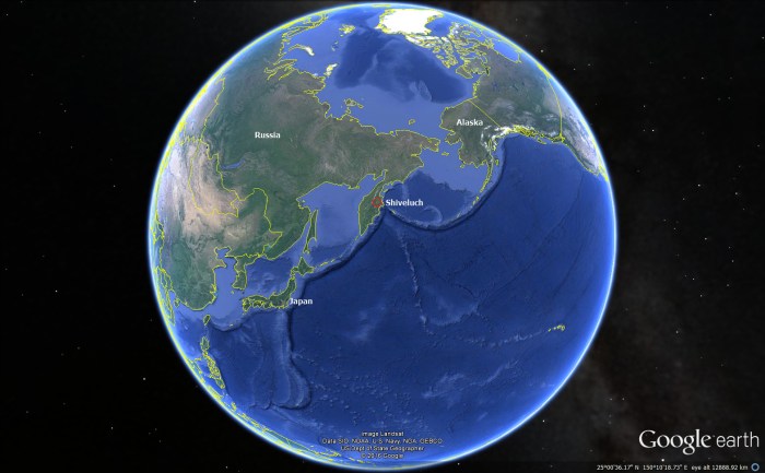
Sheveluch is another Kamcatcha volcano continuing to send plumes into the sky with one event on the 28th reaching 20000 feet and producing a pyroclastic flow (see below)
Copahue

Buenos Aires VAAC reports “light VA (Volcanic Ash) and steam” continuing to emit from Copahue.
This concludes this weeks report.
Have I missed anything??? Let me know in the comments 😀
/Hobbes


Wow, I must say that the new format is a winner. Thank you for a great update!
I absolutely agree with dorkviking! Excellent work and a big thank you!
Yes the format is good, thank you for your hard work and dedication! 🙂
Brilliant update – thanks very much!
These updates are great. Thanks Hobbes 🙂
Thanks Hobbes. I know this isn’t news, but Kilauea is still active, as it has been for the past 60 years or so. I was in Maui last week and there was a day with very bad air quality and the locals called it “Vog”.. volcanic fog from Kilauea. Since we were 100 miles from there, it suprised me. Then I looked at the Hawaiian Volcanic Observatory page, http://hvo.wr.usgs.gov/activity/kilaueastatus.php, and found that the summit was emitting SO2 at a emission rate varing between 500 and 6,500 metric tons/day. That seems a lot. What was the emission rate at Holuhruan?
400kg/s peaking at 1000kg/s
Holuhraun so2 rates
And that would be 34 560 metric tons per day on average and a peak value of 86 500 metric tons.
The Icelandic large volcanoes are immense gas bladders as they go off.
The Holohraun numbers are indeed very much higher than Kilauea. But be aware that the Kilauea numbers only refer to the summit emission. Pu’u’o’o (or however it is spelled) is not included.
Normal winds in Iceland drive the emission to the northeast, affecting rather few people. But during the eruptions winds varied, and at times even distant Ireland had air quality problems. During Laki, SO2 reportedly killed many people in the UK.
Dunno if it killed them outright, more like a lowering the odds of surviving already rough conditions. The numbers I heard were something like a 5% increase in the keeling over dead problem.
I knew there was very likely a small subglacial eruption before the main eruption at Holuhraun, but I did not know about all of the ones in this article.
http://icelandmag.visir.is/article/holuhraun-eruption-was-actually-preceded-four-sub-glacial-eruptions-bardarbunga-volcano
The one south of the caldera, marked by four red circles, reminds me of the line of quakes that extended from Bárðarbunga towards Gjálp prior to the Gjálp eruption. Carl, what’s your opinion about this?
It pans out pretty well with what we thought happened as the eruption unfurled.
Those spots are the same as where the earthquakes progressions stalled for a time before going back to forward motion.
As the eruptions occured the magma vent up instead of driving the dyke forward, as the eruptions cancelled the dyke progressed.
I would though say that the eruptions there was not substantial as stated in the article. There were brief and did not involve a lot of magma as is evidenced by the eruptions not breaching the ice layer.
Hydrothermal eruptions, perhaps?
At least two of them caused large elongated cauldrons to form and there was massive harmonic tremor, so I would say it is safe to say that those where magmatic eruptions. But we will never truly know since there were no good ice-bathymetric images of that region prior to the eruptions.
Hobbes, I am really impressed with this series. It is a lot of work but they give a brilliant overview.
They are terrific, and in a while when we have gone through a bit of articles that we are having up our sleeves the updates will give a lot of mental fodder for us to write in depth articles that we could put in between the updates.
I agree with the three spots where the dyke stalled, but there are also four red circles marked just south of the caldera that is said to count as a single eruption. It’s a bit odd, because I can only see one single quake registered in that area during that time, but it is close to (or exactly along?) where the quake activity took place just before the Gjálp eruption.
Hah. I conjectured about that at the time:
https://www.facebook.com/photo.php?fbid=10204597994099660&l=8d1d3594da
(could a moderator please make the image visible? Thanks)
GL Edit: Sorry, Faceberk won’t allow the content.
Oh heck here it is. Hopefully it’ll display…
Another great weekly update!
The picture in my gravitar are the cracks formed by that line of eruptions, the water could have ended up anywhere or most likely is still there, wonder if it played a role in stifling the eruption?
Don’t ask about the melt water running down the cracks and not into the rivers,remember 2+2=5,because we say it does😊
http://www.movieactors.com/freezes1/1984-burton-2.jpeg
Well, they wanted water…. enjoy.
… odds are they didn’t want it all at the same time. The image is the Doppler radar indicated rain accumulation. The white area is approximately 2.4 inches of precipitation.
Well, Oregon’s got sinkholes:
http://www.oregonlive.com/pacific-northwest-news/index.ssf/2016/01/landslide_sinkhole_close_down.html
Wife’s cousin lives about 4 blocks from that spot.
darn near drove the family Beemer in to it.
“Interesting” (terrifying) Glad you were able to avoid the incident. I would not have expected anything like that in Oregon… at least from a karst topology point of view. I don’t consciously think about it, but that’s one of the things that nags the back of my mind when I drive the Panama City runs. Luckily, they are not a common event, though the terrain is capable of it. It’s actually more likely to have to avoid a wandering bear than encounter a forming sinkhole. And in all of the driving I’ve done there, the only bear I have seen are on the warning signs.
I have met a wandering bear once while driving in the US. Actually it wasn’t wandering, it was more stationary and I was the wandering one in my car. Must have been a bit sleepy, early in the morning, because I remember thinking ‘what a strange cow’ and only realized the reality after having passed it.
I sometimes enjoy making my own t-shirts with weird things written on them, the more perplexing the better.
I think that “What a weird cow!” would be a winner in that department.
This was essentially a 1h 53min Chrysler commercial. I’ve been through what this truck allegedly endures and it’s a complete farce in how it turns out. The only thing really accurate is that you can have multiple vortices inside an overall uplift region. (the “core” as referred to in the clip)
https://youtu.be/vEOMfGGM6U0
According to the book on the making of the movie, the CGI cow picked up by the twister sisters was originally a CGI zebra from Jumanji (1995).
http://www.imdb.com/title/tt0117998/trivia
Yeah, Geo, all of us SC-ians complained for half a decade that we wanted more rain (Lakes Moultrie and Marion both were becoming un-navigable due to tree stumps when the lake levels dropped) and then, last October we got it. All. All at once. Here are a few of my pictures from that week.
https://www.flickr.com/photos/laconicphotog/albums/72157663242177624
http://kittenwatchesthings.tumblr.com/
Because we all have been there at the movies.
There is currently low level unrest at Hekla with minute earthquakes (below M0.5) and the Burfell strainmeter had a serious twitch. It though seems like it has calmed down now a bit.
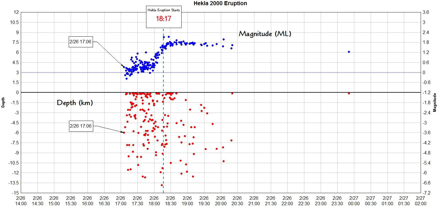
And for those who have never seen it, this is a plot of the seismic activity at Hekla from the 2000 eruption, and a good example of why Hekla’s summit is a dangerous place to hang out. The quakes of the eruption were not human perceptible until just a few minutes prior to it going full on. In part, this is because Hekla more an over grown fissure cone-row than a typical stratovolcano. Rather than having to wait until the magma pressure can overcome the resiliency of the rock, as soon as the fissure’s confining pressure is released by the two sides moving apart, if there is pressure in the chamber, it will use the newly opened path to the surface. That’s also why the strain-meters are so important at knowing when it is nearing eruption. Seismically, you might not see it until its already in progress.
Red dots are depth, blue dots are magnitude.
I have a habit of running up volcanoes that are in eruption. This is most likely not a very good idea, but I have a pretty good idea of what is possible and not to do around volcanoes, and I make damn sure to know how the particular volcano I am going to run up is behaving.
That was me going up erupting volcanoes.
Nothing on the planet could drag me up Hekla when it is dormant. I would not get any warning, and the initial eruption would kill me wherever I was on the edifice (or nearby). I would not have to worry about lavabombs or flying stuff, the initial shockwave would just rip me to very small pieces of Carl, the opening is comparable to a decent sized Nuclear bomb going off at point blank range if you are on top of the mountain. It is the single most scary volcano on the planet, and even looking at it at a distance of 10km gives me a feeling of utter dread in my stomach.
Agree, Hekla is one scary lady. This sign is posted at several places around Hekla and together with general information about Hekla it lists 10 likely ways that Hekla will kill you. The list is not complete as it does not include “ripped to pieces by shockwave”
http://www.almannavarnir.is/upload/files/Hekluplakat.pdf
Paraphrasing Randall Monroe of XKCD.com; “You stop being biology and start being physics.”
The most dangerous volcano on the planet is the one currently erupting or about to erupt.Anyone walking up Hella in the last 16 years has been perfectly fine.All about being in the wrong place at the wrong time😊
Random much? I feel like Riley Poole in National Treasure announcing “Albuquerque. See I can do it too. Snorkel.” at random.
What do you mean, Geyser? You’ve lost me.
Any volcano that is not erupting or going to erupt in the immediate future ,is not the most dangerous on the planet.Why is Hekla the most dangerous volcano on the planet?What city sits at its base?Is it erupting frequently,that on a daily basis,that if you were standing on it ,you are at at high risk on a particular day?By definition if there was a most dangerous volcano on the planet ,it would have to be located in a country with a high density population and be capable of a large enough eruption to be a risk to the lives of a significant part of that population.If you are on the flank or summit a volcano that is capable of explosive eruptions,then the danger level is basically the same no matter where it is.
You just do not get it do you?
It is the most dangerous to be on top of that is not currently erupting. Why? Because you will get no warning before it goes off.
Next, nobody knows when it will erupt, just that it is likely to be soon. It has had 3 aborted eruptions already.
And in regards of the most dangerous volcanoes of the world… We did a series of 10 of them specifying all that you asked for.
You can read all about it in Issue number 2 of the world renowned JHE.

Why is it the most dangerous? Because it can erupt with very little warning.
There are a lot of volcanoes that can erupt with very little warning.Remember the recent Ontake eruption.If you are standing near the crater of a recently active or active volcano there is always the chance of an eruption without warning and in that close proximity even a small eruption will put you at great risk.
“with very little warning”
Which is why I don’t complain when the USAF closes route 285. Nothing is important enough for me to use that route when they are playing with bombs. (it cuts through Eglin AFB.)
No, it is about knowing the dangers.
I know Hekla, better than anyone with the possible exception of Erik Sturkell.
Nothing in hell can get me to climb the bugger. If I for some odd reason would need to get up to the top that would be done with helicopter, the helicopter would be standing close by with rotor spinning. And you can be damn sure that there would be someone in constant contact with IMO while I was on top. And I would still limit the time to as few minutes as possible.
On foot you are dead if you are at the top, with a helicopter I may have a chance.
Let us make a comparison, if Hekla had been where Vesuvius are there would have been no Naples. It is that deadly. Now it sits almost pretty much all alone with a couple of desolate farms around it, and the farmers are ready to bug out for the dugout within 5 minutes, all the time, year in and year out.
The point I was making is ,that is not located where Vesuvius is and if you slept on the summit last night in a tent you would still be alive today and every day for the past 15 years for that matter.Tourists go to the White Island crater virtually every day,yet in 2013 it had an eruption that although small,would have killed anyone standing next to the crater lake,but the eruption happened at night and a few days later the tourists were back.As you say to minimize the risk you spend as little time on an active or potentially active volcano as possible.
It is individual danger versus danger to the world. Although Hekla has caused havoc in the past. But it is dangerous to tourists because of its lack of warning. A bit like walking into a busy road. Nothing may happened but oif a truck comes at you, don’t expect anyone to rescue you.
Maybe you guys could do an article,”Which volcano is the world’s most dangerous”,and go through all the factors,i.e frequency of eruption,size of potential eruption,how many people are in harms way etc.Yellowstone for example has eruption size,potential to affect a large population,but it’s eruption frequency of 600000 years means it’s not the world’s most dangerous.
And now for something completely else, the volcanoes of Saudi Arabia!
http://www.volcanocafe.org/volcanoes-of-saudi-arabia/